Vehicle-Mounted System Enables Data Capture for Road Agencies and Local Governments
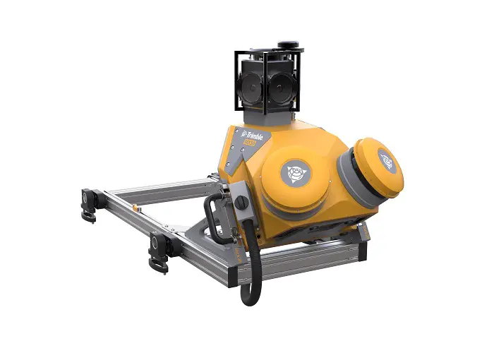
Trimble has introduced the Trimble® MX50 mobile mapping system for asset management and mapping—a new addition to its established mobile mapping portfolio. This vehicle-mounted mobile LiDAR system is a mid-range option for first-time mobile mapping users and experienced providers to expand their equipment fleet with precise, high-volume data capture technology that works in conjunction with Trimble’s geospatial software solutions.
By providing clean and accurate data of ground surfaces, the Trimble MX50 is a practical choice for highway and road inspection and maintenance organizations; city, state and local governments; public utilities; contractors; and survey companies wanting to expand their service capabilities.

The Trimble MX50 features new Trimble-designed profiling lasers for high-accuracy data collection, a 360-degree panoramic camera and a GNSS/IMU positioning system from Applanix, a Trimble Company. The system produces dense point clouds and immersive imagery for surveying and mapping accuracy, and works with Applanix POSPac, Trimble Business Center and the Trimble MX software suite. The Trimble MX50 also expands the company’s mobile mapping portfolio, which includes the widely adopted Trimble MX9 system for large scanning and mapping missions and the highly portable Trimble MX7 for capturing precisely positioned street-level imagery.
“The Trimble MX50 reduces the complexity of mobile mapping while enabling users to be more productive and efficient in mapping and managing assets, and maintaining highways and roads,” said Jacek Pietruczanis, business area Director for Mobile Mapping, Trimble Geospatial. “Combined with Trimble’s complete software field-to-finish workflow, the MX50 enables users to take control of the data they have captured from the comfort and safety of their vehicle.”
The Trimble MX50 is available now through Trimble Geospatial Distribution Partners. For more information, visit: geospatial.trimble.com/products-and-solutions/trimble-mx50.
About Trimble Geospatial
Trimble Geospatial provides solutions that facilitate high-quality, productive workflows and information exchange, driving value for a global and diverse customer base of surveyors, engineering and GIS service companies, governments, utilities and transportation authorities. Trimble’s innovative technologies include integrated sensors, field applications, real-time communications and office software for processing, modeling and data analytics. Using Trimble solutions, organizations can capture the most accurate spatial data and transform it into intelligence to deliver increased productivity and improved decision-making. Whether enabling more efficient use of natural resources or enhancing the performance and lifecycle of civil infrastructure, timely and reliable geospatial information is at the core of Trimble’s solutions to transform the way work is done. For more information, visit: geospatial.trimble.com.
About Trimble
Trimble is transforming the way the world works by delivering products and services that connect the physical and digital worlds. Core technologies in positioning, modeling, connectivity and data analytics enable customers to improve productivity, quality, safety and sustainability. From purpose built products to enterprise lifecycle solutions, Trimble software, hardware and services are transforming industries such as agriculture, construction, geospatial and transportation. For more information about Trimble (NASDAQ:TRMB), visit: www.trimble.com.
Also Read
Trimble Webinar: What’s new in TBC 5.20 Mobile Mapping Module