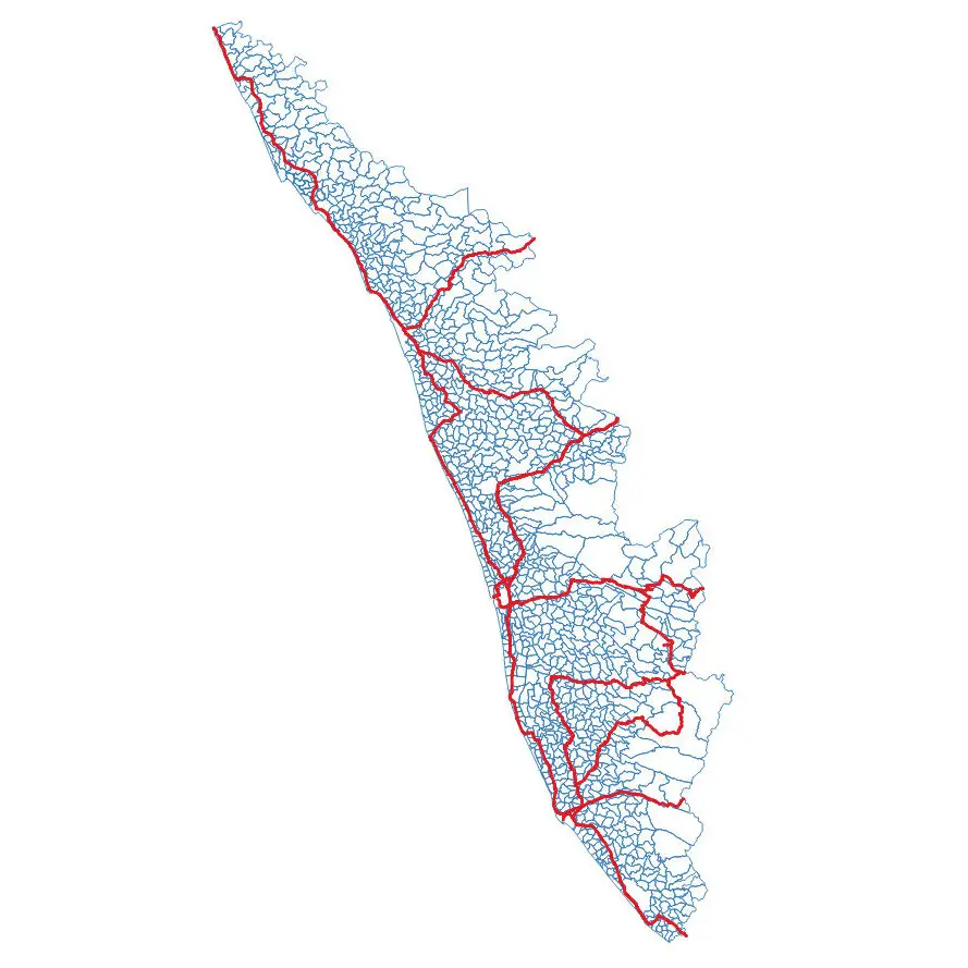
OSM Kerala Community Releases Local Body Boundary Map of Kerala
Recently OSM Kerala Community has released a free Local Body boundary map of Kerala. The data have map boundaries added for Corporations, Municipalities, and Gram Panchayat.
As part of Kerala Open data initiative by Kerala IT Mission and OSM Kerala Community, plans to map roads and buildings in Kerala
In Kerala there are 1200 Local Self Government Institutions (LSGIs) which includes
- 941 are Grama Panchayats,
- 152 are Block Panchayats,
- 14 are District Panchayats and
- 87 are Municipalities & 6 Municipal Corporations.
Each local body, except District Panchayath is divided into wards
- Corporations
- Municipalities
- Gram panchayat
- District panchayat – All Gram Panchayats in District
- Block panchayat
Easy Data Download Link (Github)
The open-source maps will be useful in visualizing and sharing geospatial or geographic data as an interactive map.
The Local Body boundary map data is available in Geojson, KML and Shape file Formats. The vector maps are also being added to Wikipedia pages of panchayats in the state. The maps generated by the community would be available for download under Open Database Licence (ODbL) on websites openstreetmap.org and opendatakerala.org.
The mapping exercise took around four months. Once ward-level layers are added, such maps would also be useful during local-body elections.
The local body boundary map up toward levels was prepared by the Information Kerala Mission (IKM) and Kerala State Remote Sensing and Environment Centre (KSRSEC).
Interestingly, most of the mapping using publicly available documents was carried out by a German national, Heinz Vieth, who volunteered to help the community.
The non-availability of data on public domain and their unwillingness to share them with other departments had caused many difficulties. Hopefully more similar data open-source and accurate will be created and available for the rest of India.
Kudos to OSM Kerala Community!
Also Read –
- Kochi Metro Rail Completes LiDAR Survey for Kochi Water Metro
- Kerala Launches GIS-based Land Information System
- Space-based Services Should be Used: Kerala Tourism Minister
Source – Open Data Kerala and ToI