NavVis IndoorViewer Now Converts Static Scans Into Immersive 360° Imagery
New software feature brings full functionality of IndoorViewer to structured E57 point cloud files
MUNICH, Germany, October 8th, 2018 – NavVis, a leading provider of indoor spatial intelligence technology, can now automatically convert E57 point cloud files into interactive, realistic 360° walkthroughs, following the latest software upgrade to IndoorViewer.
NavVis IndoorViewer is a web-based application that displays realistic digital twins using 360° panoramic images, point clouds and maps generated by 3D scanning devices. Users can move around digital twins of scanned spaces as if they are on site and use the interactive functionality to add, search for and route to geo-tagged information and take accurate measurements.
The intuitive user interface and functionality has made NavVis IndoorViewer a valuable deliverable for laser scanning professionals who want to extend the use of point clouds beyond BIM models and building plans to a wider range of building stakeholders who would also benefit from 3D scan data. This is particularly relevant for stakeholders working on complex projects or properties, such as manufacturing facilities and construction sites, where IndoorViewer enables remote access to the site and is used as a platform for collaboration and exchanging information.
“IndoorViewer was originally developed to display the data captured by our indoor mobile mapping system in a way that is accessible to every user. In recent years, we have seen that making scan data available to every building stakeholder is fulfilling an unmet need. Many of our partners using a NavVis indoor mobile mapping system for conventional scanning projects are offering IndoorViewer as an additional deliverable to increase the number of stakeholders who can make use of this data,” said Felix Reinshagen, NavVis CEO.
“To meet the growing demand for extending the use of valuable 3D scan data, we developed a feature that automatically renders 360° immersive images from structured E57 point cloud files. The latest software release brings the full functionality of IndoorViewer to E57 point cloud files and therefore marks an important step towards our goal of making scan data meaningful for every building stakeholder.”
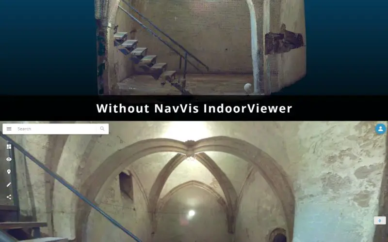
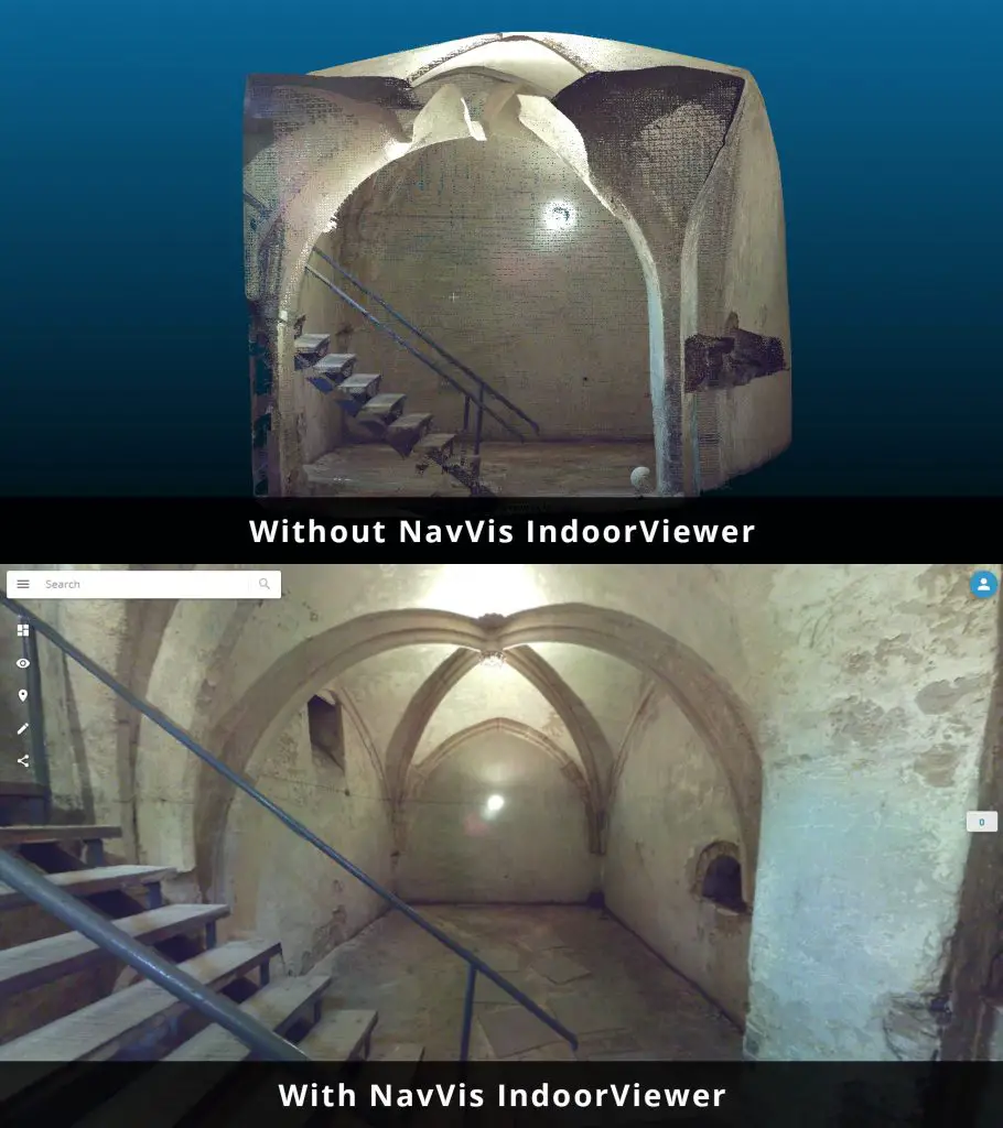
NavVis IndoorViewer currently supports third party point cloud files in most standard formats. However, a key component of the immersive experience that NavVis IndoorViewer provides is the 360° panoramic images. The new IndoorViewer feature bridges this gap for structured E57 files by automatically rendering 360° immersive imagery from E57 point cloud files. This means data collected by terrestrial laser scanners can now also be used to create realistic, immersive 360° walkthroughs that can be published and shared online without the need to download or install software.
The E57 panorama extractor is available as part of a free software upgrade to IndoorViewer subscribers. For more information about NavVis IndoorViewer visit: https://www.navvis.com/indoorviewer
Visitors to InterGeo 2018 can demo the new NavVis IndoorViewer release as well as the NavVis M6 indoor mobile mapping system by visiting NavVis in Hall 12.1 at booth 12.1D.086.
For more information, please contact:
Munich Office:
Viktoria Langley
T: (+49) 89 7169 250 20
E: press@navvis.com
New York Office:
Evan McPhee
T: (+1) (646) 714-7016
E: press@navvis.com
About NavVis:
NavVis is a leading provider of spatial intelligence technology for large commercial and industrial properties. Our cutting edge indoor mapping, visualization and navigation technology is being applied in every industry that uses, manages or builds indoor space. Digital building technology is benefitting everything from construction monitoring, facility management, and manufacturing, to transportation hubs and multi-channel retailing.
Graphic Caption: Top image shows E57 point cloud file captured by static laser scanner. Bottom image shows E57 point cloud after being automatically converted to 360-degree immersive walkthrough with NavVis IndoorViewer.