GOLDEN, Colorado, 13 November 2018 – Golden Software, a developer of affordable scientific graphics software, has enhanced the visualization capabilities in version 16 of its Surfer® gridding, contouring and 3D surface mapping package. Geologists, environmental consultants, and geospatial professionals will find Surfer 16 makes it easier for them to interpret complex scientific data.
“We have improved every aspect of core functionality in Surfer 16 so it’s faster and easier to make meaningful custom maps,” said Golden Software CEO Blakelee Mills. “Surfer users will find the new version generates more accurate representations of physical, chemical and structural properties, allowing them to make better decisions.”
Surfer is a robust 3D data visualization and mapping software that routinely outperforms more expensive packages. It enables users to model their data sets, apply an array of advanced analytics tools, and graphically communicate the results in ways anyone can understand. Known for its fast and powerful contouring algorithms, Surfer is used extensively by geologists in mining and oil & gas activities and by hydrologists in environmental monitoring projects.
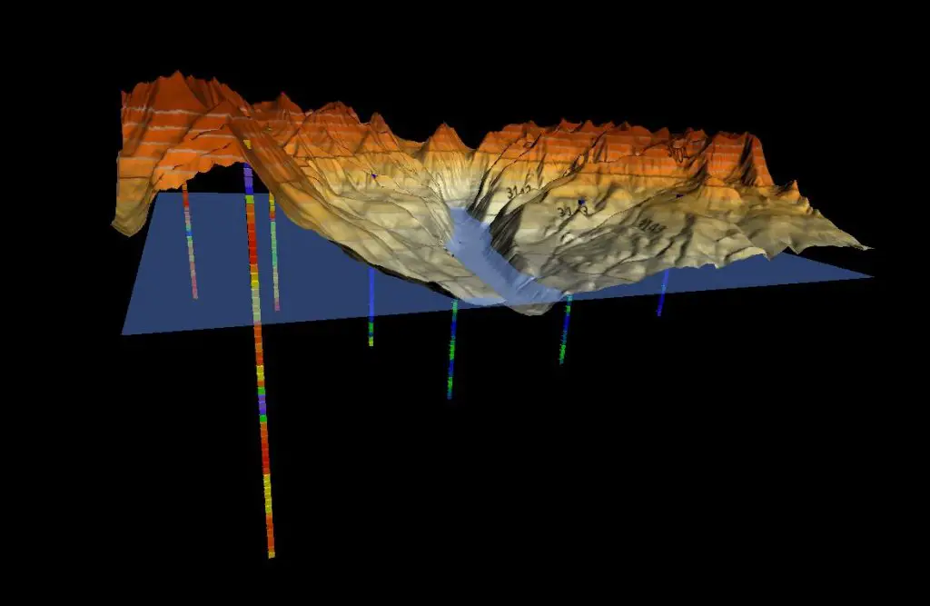
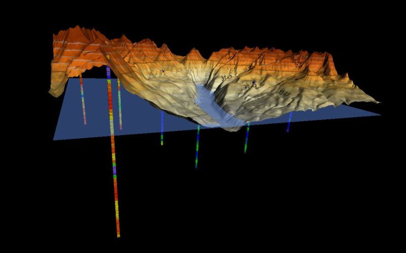
Topographic surface with well sample data and water level.
The primary improvements in Surfer 16 have been made in the color mapping and Contour Map capabilities:
Equal Area Stretch – Similar to Histogram Equalization, this new feature lets the user stretch colors across the distribution of data, creating a proportionate representation of the data variation and enhancing the visualization’s contrast. This means that tightly distributed data can be displayed as quickly varying colors in the generated colormap, making it easier to spot anomalies in data values. Colors can be stretched automatically or manually across the histogram of data values.
Equal Area Contouring – Another new feature added to surface mapping functionality, Equal Area Contouring allows the user to calculate the geographic distribution of contours so they align more precisely with the geophysical data they represent. This results in a more accurate visualization of geophysical data sets, which are seldom linearly distributed.
“The combination of Equal Area Stretch and Contouring creates striking visual maps that vividly highlight data distribution,” said Mills. “This makes it easier to interpret and understand geophysical and geochemical concentrations in the subsurface.”
Surfer 16 includes three other important enhancements:
True 3D Point Data – Surfer has always accurately displayed LiDAR point cloud data, and this 3D visualization capability has been expanded. Now any 3D vector data can be represented in three dimensions in 3D View. Clients who use Surfer to visualize subsurface wells can use this to display the well path. It can also be applied to quickly check the quality of 3D grids.
Enhanced Attribute Management – Surfer now has commands to calculate geometry – such as area or perimeter length – and add those values to object attributes. These calculations can be performed either to create new attributes or modify existing ones with updated information. One of the key advantages of this enhancement is that area data can be normalized and attributed to objects for generation of more accurate choropleth maps.
Kriging with External Drift – Surfer is known for its powerful kriging functions, and this capability is even better in v16 with the addition of Kriging with External Drift. This allows users to add a secondary data set for use as a proxy in interpolating the primary data set with the goal of yielding better estimated values. Surfer users asked for this new function because it typically lets them obtain and use less expensive data sets to supplement a more expensive one.
“Surfer has a reputation for high-quality graphic outputs, powerful gridding algorithms, and ease of use – and we have improved each of these capabilities in Surfer 16,” said Mills.
About Golden Software
Founded in 1983, Golden Software is a leading developer of affordable scientific graphics software. Its customer base includes over 100,000 users involved in environmental consulting, oil and gas exploration and extraction, mining exploration and extraction, engineering, applied science, business, education, and government in 186 countries and territories. Golden Software offers six products: Surfer® for gridding, contouring and 3D surface mapping; Voxler® for 3D data visualization; Grapher™ for 2D and 3D graphing; Strater® for well log, borehole and cross section plotting; MapViewer™ for thematic mapping and spatial analysis; and Didger® for digitizing and coordinate conversion.
For additional information, visit www.GoldenSoftware.com or call 1-303-279-1021.