In the last 2 decades, India’s urban population has increased exponentially with 33% of the population living in cities in 2015. Experts estimate that urbanization will peak in 2050, with more than half of India’s population living in cities. The growth rate of small and medium-sized towns in India is much higher than its metropolitan cities, which in recent years, have seen their population decline but grow on their peripheries.
Urban development is largely based on Master Plans of the Metro/City. Depending on priorities and funds the development activity is taken up. However the pace of development undertaken by the town planning department is far behind the unplanned growth of settlements coming up in the periphery of metros and towns which are inhabited by economically mobile migrant settlers, seeking better economic prospects in urban areas. By the time the urban development local bodies reach these outer settlements with their development plans, more settlements have arisen further around the urban areas. This is a viscous cycle, with layer upon layer of unplanned growth being added where development is always far behind.
Due to this unplanned growth, habitations arise and perpetuate that have overriding aspect of squalor and unsanitary physical conditions. There is a complete lack of civic amenities that deny its habitants of any sense of dignified living. However, the fact remains that the residents of such settlements are also citizens of the Indian Republic and as a consequence have the right to partake of the opportunities inherent in urban living.
The view that cities are central to the country’s economic growth and development is gaining wider acceptance, strengthened by the increasing contribution of the urban sector to India’s GDP. According to estimates by several studies and reports, Indian cities are likely to account for nearly 70% of India’s GDP by 2030. Hence there is a need to make our urban areas more efficient.
Realising the need for Urban Development and Renewal, the Government of India has undertaken several projects. Earlier the Jawaharlal Nehru National Urban Renewal Mission (JNNURM) in December 2005 brought the urban development agenda into focus through planned development, redevelopment and renewal of cities, city centres, urban areas, outgrowths, settlements and urban corridors; the recent Smart Cities Mission, started in June 2016, has sought to undertake retrofit and redevelopment of urban areas of 100 cities and the Heritage City Development and Augmentation Yojana (HRIDAY) is being implemented with the overall objective of revitalising heritage cities.
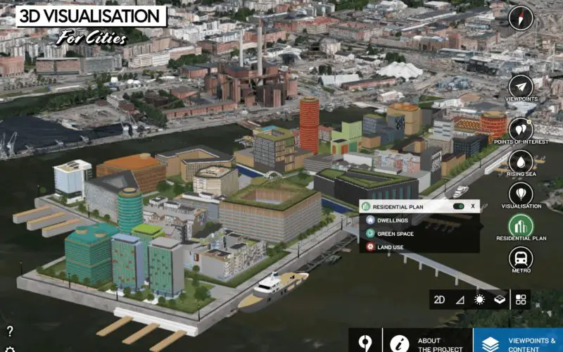
Geospatial Technologies play a vital role in the survey and data capture of existing urban areas that require redevelopment. Supplemented by extensive data collection and analysis, these technologies can be used to create scenarios and decision-making models that incorporate smart solutions, innovation, best practices and new technology that enable efficient & planned growth.
Geospatial Technologies can be used to generate futuristic projections about urban growth areas. With the help of these technologies urban local bodies can plan development in such areas to ensure planned growth that provide basic urban services such as water, electricity, opportunities for livelihood & recreation, provide for nature & natural spaces, sanitation, sewerage and transportation as well as implement green building concepts such as water harvesting, conservation and reuse, efficient energy generation and use and the use of efficient information and telecommunication technologies.
The December 2019 edition of the magazine feature articles on the implementation and role of geospatial technologies in the urban redevelopment.