 Geographic Information Systems Department of Dubai Municipality has released Makani, an e-map application for iPhone and Android phones.
To make Makani a user-friendly for the residents of Dubai, the app is developed with bi-lingual (English and Arabic) option.
This app will allow finding accurate Geo Address locations by using the Makani Number. Makani Geo Address, also known as Makani Number, is a unique identifier comprising of 10 digits. The 10 digits of unique identifier for each unique spatial entity represents, 5 digits for easting and 5 digits for northing that is assigned to each entrance of the buildings in the Emirate of Dubai.
This app is using UAE NG (UAE National Grid) coordinates which is based on the MGRS to define the locations. To add something more interesting to the app, it allows coordinate conversion to popular formats like Universal Transverse Mercator (UTM), Geographic Coordinate System (GCS) to make compatible with devices like smart phones which depends on global navigation satellite system (GNSS) to locate their positions.
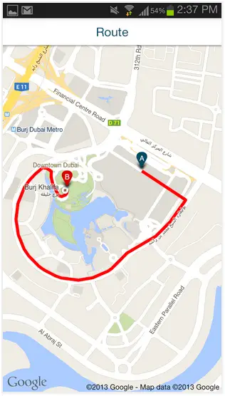
Image Source: Google Play
Makani allows you to find directions between two locations, to find the nearest services like government, health, education, landmarks etc., to share locations with friends, colleagues via sms, email or social networking like Facebook, Twitter etc.
“If your friend is in Dubai Mall and you are wondering where to find him, he can locate himself if connected to Wifi. After he has sent you the coordinates, the application will flag his location on your screen,” says Abdul Hakim.
Although the application has sufficient accuracy to support a pedestrian, it is mainly intended to guide the driver, said Abdul Hakim.
“The numbering of locations in Dubai has been completed, and at the moment we are double-checking these numbers. We have completed 50 per cent of this double-check and by March next year, we should be able to release the GIS coordinates,” – Abdul Hakim.
Meanwhile, residents can download and use the ‘Makani’ application. But the second version, which will be launched in January, will be much better, he says.
There is an desktop application is also available for Makani, to have an experience please visit: http://www.makani.ae/desktop/mylocation.asp?value=