Crowdsourcing to Facilitate Earthquake Early Warning Implementation to Reduce the Impact of Future Earthquakes
The 7.9-magnitude earthquake that struck Nepal on August 25, 2015 has killed more than 5,000 people. Many thousands have been injured and hundreds are still missing or trapped under rubble.
Earthquakes are among the most deadly natural hazards and one of the biggest unsolved puzzles for human beings in terms of prediction. An earthquake is the result of a sudden release of energy in the Earth’s crust that creates seismic waves.
In a study by Sarah E. Minson et. al., has come up with a solution for earthquake early warning system. Earthquake early warning (EEW) can reduce harm to people and infrastructure from earthquakes and tsunamis, but it has not been implemented in most high earthquake-risk regions because of prohibitive cost.
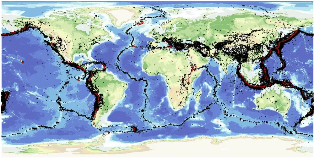
A map of the world’s earthquakes shows that most of them lie in narrow zones, often around the edges of the continents, or in the middle of the oceans
Earthquake early warning (EEW) strives to detect an earthquake’s initiation, estimate its location and magnitude, and alert people and automated systems to imminent shaking. Commercial demand for personal mobile navigation has led to a proliferation of devices that use the same, albeit lower-quality, GNSS and Inertial Navigation Systems (INS) sensors used for earthquake early warning. Smartphones alone currently number 1 billion worldwide and will increase to ~5.9 billion by 2019. The ubiquity of consumer devices raises the possibility that operational EEW could be achieved via crowdsourcing. For a global population exposed to ever-increasing earthquake risk, the significantly reduced costs associated with crowdsourcing could facilitate widespread earthquake early warning (EEW) implementation and substantially reduce the impact of future earthquakes.
Although there has already been exploration of the potential of scientific seismic and GPS data, as well as consumer-quality accelerometers, for earthquake early warning (EEW) and tsunami early warning, the potential of consumer-quality GNSS receivers remains untapped.
The study present a conceptual strategy for a crowdsourced EEW system that includes device use, data processing and quality control, earthquake detection, false alarm suppression, earthquake location, and magnitude determination that could be used to extend the benefits of EEW worldwide.
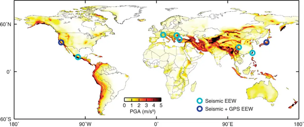
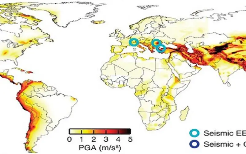
Global seismic hazard and extent of EEW.
Symbols show the few regions of the world where public citizens and organizations currently receive earthquake warnings and the types of data used to generate those warnings. Background color is peak ground acceleration with 10% probability of exceedance in 50 years from the Global Seismic Hazard Assessment Program.
The study harnesses the potential performance of smartphones and a crowdsourced EEW system in three ways. First, the researcher team performs controlled tests on a variety of consumer devices to determine their noise character and displacement detection capability. Second, for a scenario Mw 7 rupture on northern California’s Hayward fault, researchers generate synthetic smartphone accelerometer and GNSS time series for different data types they may obtain from crowdsourcing at random locations based on census population data. Finally, they consider GPS position time series of an actual earthquake, the Mw 9.0 Tohoku-Oki event, obtained using positioning data of the type found on consumer devices.
To obtain surface displacement observations for EEW, it is the instrument’s change in position that must be measured accurately; absolute position is used only for spatial reference. Consumer devices typically use single-frequency, C/A (coarse acquisition) code methods for GNSS positioning rather than the more precise and accurate locations derived from dual-frequency, carrier phase–based algorithms used in scientific applications. These C/A code positions can be substantially improved by using differential corrections via satellite-based augmentation systems (SBAS), tracking the more precise GNSS carrier phase and using it to filter the C/A code data (“phase smoothing”)or by combination with independent INS data in a Kalman filter. Today’s smartphones have some or all of these capabilities.
Earthquake early warning has had encouraging initial results, although two issues impede performance and wider implementation. First, magnitude estimates are unreliable for larger earthquakes [moment magnitude (Mw) >7] when based solely on brief observations of the earliest seismic waves. This can be overcome by using observations from Global Navigation Satellite Systems (GNSS) such as the Global Positioning System (GPS). Second, it is expensive to install and operate the required dense seismic and GNSS networks. Nevertheless, even well-monitored regions such as California, Oregon, and Washington require extensive expansion and upgrade of existing instrumentation, including installing hundreds of new instruments, to implement EEW. Consequently, seismic EEW is operational in a handful of regions, and only a few of those (Japan, Mexico, and the United States) are incorporating GNSS data into their systems. Much of the global population exposed to high seismic risk, especially in poorer countries, does not benefit from EEW.
The results demonstrate that the GNSS and INS navigational sensors built into consumer devices such as smartphones are capable of detecting surface displacements from moderate and larger earthquakes. This economical approach warrants further development, although do not suggest that it is a substitute where monitoring of smaller, but still potentially destructive, earthquakes is required. In regions where resources cannot be allocated for scientific-grade EEW due to limited financial resources or less frequent occurrence of destructive earthquakes, crowdsourced EEW may be the best option.
– Crowdsourced earthquake early warning