From military intelligence to business intelligence
![]() Far from its traditional image as the publisher of leisure maps for ramblers and cyclists exploring idyllic countryside, where the only disturbance is the rustle of a cagoule or the whirr of a freewheel, Ordnance Survey was set up in preparation for war and had a major role to play in the mapping of World War One.
Far from its traditional image as the publisher of leisure maps for ramblers and cyclists exploring idyllic countryside, where the only disturbance is the rustle of a cagoule or the whirr of a freewheel, Ordnance Survey was set up in preparation for war and had a major role to play in the mapping of World War One.
Today many people still know Ordnance Survey for its iconic range of paper maps; however, cutting-edge digital products for business now make up around 93% of the organisation’s revenue. Ordnance Survey has a surprising history, because as Britain’s national mapping authority, today’s suppliers of business intelligence were originally charged with gathering military intelligence.
Preparing for war
In 1791, when it looked as though the chaos of revolution might travel across the water from France, the Government of William Pitt the Younger asked the Board of Ordnance – the Ministry of Defence of Georgian Britain – to survey and map the Channel coast of Southern England in preparation for invasion.
Although the Survey has its roots firmly in the military, perhaps its biggest war-time challenge occurred as the business it is known for, now started to emerge. Set against the backdrop of new civilian responsibilities – producing maps for land valuation and tax purposes – and the Edwardian love of exploration that fuelled a growth in sales of its leisure maps, the First World War saw the Survey embark upon an urgent military task of heroic proportions; with existing maps of France found inaccurate and unreliable, it re-mapped around 6,000 square miles of the Western Front.
The ‘Astrologer’ and some innovative techniques
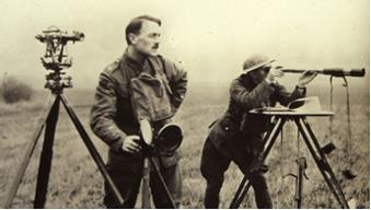
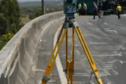
Surveying during World War One
Like most Herculean exercises of its kind, the survey of the Western Front didn’t always go to plan. In late January, 1915, somewhere on the front lines between Béthune and Ypres the first surveyor sent out into the field was arrested as a spy on the grounds that no-one except a German would be likely to use an instrument such as a theodolite in the area. He was quickly released and allowed to continue, but the story – as told by Captain Winterbotham of the 1st Ranging Section of the Royal Engineers – underlines what must have seemed a curious sight to the average soldier at the time. Winterbotham himself was no stranger to attracting attention and became something of a celebrity by being able to direct artillery fire accurately onto unseen German positions – a feat which earned him the nickname of ‘the astrologer’.
The urgency of the task followed a change in the very nature of the war itself. From Britain’s declaration of war on 4 August, 1914, it took little more than a month for trench warfare to emerge as the dominant form of conflict. It was a war that Britain’s generals and military tacticians, familiar with colonial conflict and cavalry charges, were at a loss to fight. This was a war that was industrial in scale, featured advanced defence systems and horrifying firepower; their only tactic against the organised trenches of the German Army, the traditional massed infantry advance, proved to be nothing more than a suicide mission.
By spring 1915, both sides were installed in 200-mile long networks of trenches strung between the Belgian coast and Switzerland. The stalemate was made worse by the terrifying power of machine gun fire, long-range artillery attack and chemical weapons; static warfare demanded new tactics and, where advances were counted in yards, large-scale, highly-detailed mapping.
Ready for action
Ordnance Survey was already prepared for war at its outbreak. Three survey sections were ready for action, but the War Office stood them down, possibly because the prevailing attitude was that the war would be quick – all over by Christmas, in fact – much to the disappointment of thousands of eager volunteers queuing up at recruiting offices up and down the land. A fast campaign that overcame resistance quickly could use existing, less detailed mapping, such as the small-scale 1:80 000 maps produced by Ordnance Survey’s French counterparts. The Government’s optimism was short-lived, but the early successes of Winterbotham, in particular, encouraged the Army to form surveying sections, then companies and, finally, field survey battalions.
Mapping the front line
Working near the front lines, the Ordnance Survey men routinely exposed themselves to danger – enemy (and occasionally ‘friendly’) fire, were common. As if the prospect of being
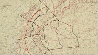
1917 trench map, based on an Ordnance Survay map
shot wasn’t enough, the act of surveying itself was demanding and difficult and required the utmost care in an environment that changed so rapidly. A prominent building, like a church tower, that could be used as a landmark to anchor the map to a fixed point in the landscape, would often end up demolished by artillery. Worse still, a church tower might be re-erected fifty yards away from its original position, potentially throwing the accuracy of the map out enough to make a real difference to an operation or manoeuvre.
The start of aerial photography and modern techniques
Another difficulty – of obtaining information about German trench and artillery positions – was solved early on with the rapid development of aerial reconnaissance. These days, Ordnance Survey operate two aircraft solely devoted to aerial survey (they notch up around 80,000 km a year as part of the Survey’s ongoing work to update its digital master map of Britain), but in 1914, the technique was very much in its infancy and the photographs taken had to be corrected to match the projection of the map.
Along with rapidly developing aerial reconnaissance techniques – radio signals were used as beacons for the first time to synchronise sightings of observation planes over enemy positions – sophisticated ranging by both the sound and flash of enemy guns allowed German artillery to be plotted with high accuracy. A survey of captured ground after 1917’s Battle of Messines – an offensive that set the stage for the 3rd Battle of Ypres – found that 90% of German artillery positions had been accurately targeted.
As time wore on, Ordnance Survey staff recruited into the survey battalions of the Royal Engineers – and the maps they produced, each the result of a detailed and painstaking topographic survey – overcame enough of the difficulties to contribute invaluable information for the war effort.
Printing on the battlefield
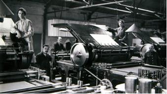
Printing maps during World War One
The military maps – around 33 million of them were printed – became more and more vital as the war wore on. Worries that ships carrying maps from Southampton might be sunk in the Channell, led in 1917 to the formation of the Overseas Branch of the Ordnance Survey (OBOS), a unit of 103 men and 46 women based in an old factory near the Aire Canal at Wardreques in France. In one period of two weeks while Field Survey Companies were forced into retreat during the German offensive on the Somme in 1918, OBOS printed 300,000 maps.
Sixty seven Ordnance Survey staff were killed during the war and they are commemorated at a memorial in a peaceful garden besides Ordnance Survey’s head office in Southampton. Without their sacrifice or the sacrifices of more fortunate colleagues, many more of their countrymen would have been killed or injured.
Modern day
The effects of the work of today’s Ordnance Survey, a self-funding civilian government department, may not be as obviously urgent, but as a contributor to wider society, business and, yes, leisure, its contribution to the Britain of today is as vital to our peacetime interests as it was on the Western Front.
Download hi-res versions of the images featured:
Surveying during World War One
1917 trench map, based on an Ordnance Survay map.
Printing maps during World War One
Contact us
For more information:
Contact: Rob Andrews, Head of Corporate Communications