Contributed By:-

According to the Texas Comptroller, the state of Texas spends nearly $6 million per year on public infrastructure, including highways and other repairs and maintenance activities. Local spending per capita in Texas is nearly double state spending, in some cases resulting in local debt as municipalities and cities try to keep up with growth and replace aging infrastructure.As a result, cities, and states are looking for a more efficient way to identify and prioritize infrastructure spending needs. Recent developments in UAV surveying and mapping technologies have opened up the door for municipalities to become more efficient and reduce operating costs. While photogrammetry is a great tool for geospatial analysis, it could be an overkill for certain projects. The georeferenced aerial video has been proven to provide a rapid, cost-efficient, approach to mapping public infrastructure, from both the street level and from the air at lower altitudes (not exceeding 400 feet) per FAA’s guidelines.
Benefits of Georeferenced Video
There is a sheer benefit to video as it provides contentious coverage of the site of interest without having to flip through hundreds, if not thousands of images. When a video is georeferenced, a viewer can see the location of the camera on the map and follow the video path as it progresses over time. Video mapping requires very little investment in hardware and could be collected with any off the shelf unmanned aerial vehicles. Geovideos do not require processing time as they can be uploaded immediately to the cloud and then viewed in a web browser. The flowchart below compares a typical Geovideo workflow to photogrammetry workflow.

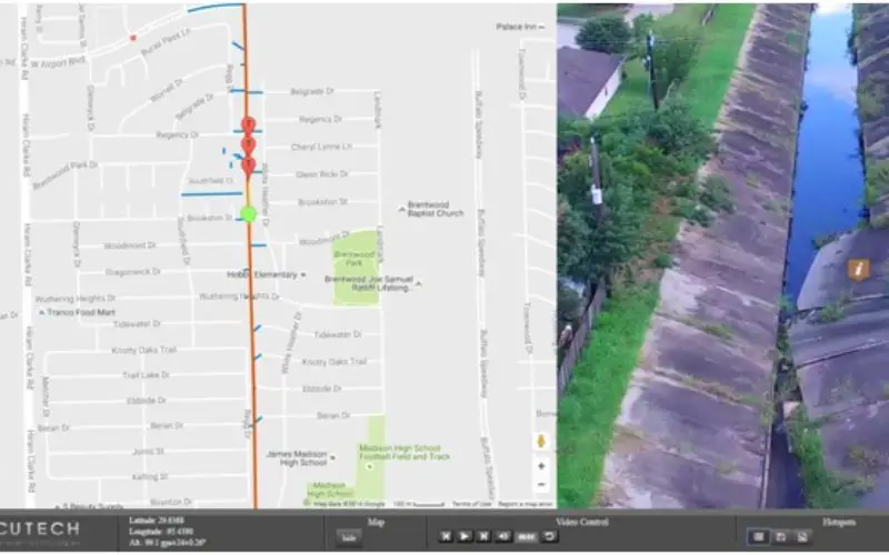
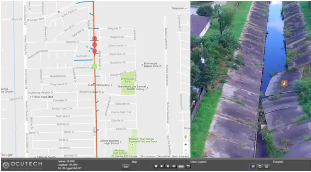
Case Study: Aerial Video Mapping for Water Corridors
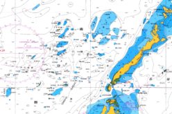
As one of the nation’s largest cities (4th in population, 9th in land area), Houston’s drainage network extends over an area of nearly 2500 square kilometers.This area is difficult and time-consuming to inspect, therefore expensive to do on foot; with the significant rain events that occur in Houston, The City’s Public Works and Engineering (PWE) department needed to complete the assessment as efficiently as possible, water corridors varied in width from 1 meter to 18 meters at some locations. The City was trying to quickly identify any defects or blockages in the corridors that needed to be addressed. Photogrammetry would have been too expensive and time-consuming process, especially when using Ground Control Points.
The Solution
Using OcuTech360’s off the shelf UAV with UHD video camera, 160 km were inspected in less than 20 days. The process was as simple as collecting aerial videos and then uploading the files with their associated GPS data into OcuTech’s web-based video software (OcuMap), where the engineer can be sitting inside the office flying over the project and geotagging defects along the corridor. This information enabled rapid accessibility to PWE engineers and decision makers from the comfort of their office, enabling better and faster decision making and prioritization. Adding to the value and efficiency, the video map served as a reference for planning and as a baseline for comparison with future assessments. Stakeholders are now able to view the data from any location by simply logging in to the secure web viewer.
Conclusion
While photogrammetry provides accurately georeferenced digital models, it may not be the best solution for mapping corridors, more so, the audience for photogrammetry is typically GIS professionals, surveyors, and engineers, while the audience for georeferenced video is typically upper management and maintenance who are looking to relatively identify the location of concern. Geovideo is a faster, easier, and more cost-effective method than photogrammetry as it requires no processing time, no GCPs, and no GIS expertise to interact with the data. OcuMapis making it possible for anyone who can capture a georeferenced video to simply upload, view and geotag points of interest without any special GIS expertise.
Author Correspondence
Ala’ Hamdan
Email: ala@ocutech360.com
Direct: +1 281-702-9495,
Office: +1 713-357-7547