Free GIS Data Portals
General GIS Data Portals
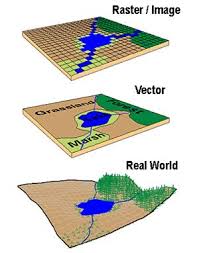
- Natural Earth – Vector: Includes coastline, land, oceans, islands, rivers, lakes, glaciated areas and bathymetry. Available at multiple levels of detail.
- Natural Earth – Raster: Includes various raster images, intended for use as backgrounds for other data, for example hypsometric tints, satellite derived land cover, shaded relief etc.
-
style="text-align: justify;">Global Map: A set of consistent GIS layers covering the whole globe at 1km resolution including: transportation, elevation, drainage, vegetation, administrative boundaries, land cover, land use and population centres. Produced by the International Steering Committee on Global Mapping. Registration Required
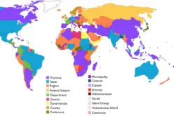
- DIVA-GIS Country Data: A collection of data collected from a number of the sources below – includes administrative areas, inland water, roads and railways, elevation, land cover, population and climate. Probably the easiest place to get a simple set of data for a specific country.
- UNEP GEOdata: A wide range of data from the United Nations Environment Programme including Global Forest Cover, Global Potential Evapotranspiration, Global Average Monthly Temperatures, Dams, Watershed Boundaries and much more. To get data, choose Advanced Search and select Geospatial Data Sets from the top drop-down link
- Koordinates: GIS data aggregation site including data in a number of categories such as elevation, environment, climate etc. Some global datasets, some based on continents, some for specific countries. Mostly vector, but some raster. Registration required
- MapCruzin: GIS aggregation site including wide range of data for various areas of the world. Some datasets appears to be of low quality, but others are good.
- GeoNetwork: GIS aggregation site including a wide range of data under various categories (both human and physical).
- European Environment Agency: Maps and datasets from the European Environment Agency, covering a huge range of physical geography and environmental topics. Europe only.
- UNEP GEOdata: A wide range of data from the United Nations Environment Programme including Nighttime Lights, Pollutant Emissions, Commercial Shipping Activity, Protected Areas and Administrative Boundaries.To get data, choose Advanced Search and select Geospatial Data Sets from the top drop-down link
- World Bank Geodata: A wide range of World Bank datasets converted to KML format, includes GNP, schooling and financial data.
- Humanitarian Response Common and Fundamental Operational Datasets Registry: List of freely available datasets for many countries run by the UN Humanitarian Response programme. Contains administrative boundaries, transport, population and more.
- Atlas of the Biosphere: Gridded human data including per capita oil usage, literacy rate, population growth rate, built-up land and many more.
- Koordinates: GIS data aggregation site including data in a number of categories such as administrative boundaries, transportation etc. Some global datasets, some based on continents, some for specific countries. Mostly vector, but some raster.
- GISTPortal: Wide range of GIS data from a project funded by UNAID to provide spatial data for humanitarian purposes.
- ESPON Grid Data: Various human geography indicators in gridded raster form across Europe, including GDP, population and unemployment in 2003 and 2006.
- MapCruzin: GIS aggregation site including wide range of data for various areas of the world. Some data appears to be of low quality, but others are good.
- GeoNetwork: GIS aggregation site including a wide range of data under various categories (both human and physical).
- Google Maps Gallery: A wide range of user-submitted geographic data, available as a KML file.
Note: The author did not suggest data accuracy or correctness. Data may be inaccurate or wrong.
Categories:
GIS Data