In 1884, the International Meridian Conference recommended that the prime meridian “to be employed as a common zero of longitude and standard of time-reckoning throughout the globe” pass through the “centre of the transit instrument at the Observatory of Greenwich”.
Today, when you visit the meridian line must walk east approximately 102 m before their satellite navigation receivers indicate zero longitude. This offset can be accounted for by the difference between astronomical and geodetic coordinates i.e. deflection of the vertical—in the east–west direction at Greenwich.
In a study by Stephen Malys et al., has accounted for by the difference between astronomical and geodetic coordinates which causes longitudinal shift in Greenwich meridian.
The coordinates of satellite-navigation receivers are provided in reference frames that are related to the geocentric reference frame introduced by the Bureau International de l’Heure (BIH) in 1984. This BIH Terrestrial System provided the basis for orientation of subsequent geocentric reference frames, including all realizations of the World Geodetic System 1984 and the International Terrestrial Reference Frame. Despite the lateral offset of the original and current zero-longitude lines at Greenwich, the orientation of the meridian plane used to measure Universal Time has remained essentially unchanged.
The situation at Greenwich
The Airy Transit Circle is a nineteenth-century telescopic instrument at the Royal Observatory, Greenwich, famous as the origin for global longitude. Today, its longitude is 00∘00′05.3′′W in the International Terrestrial Reference Frame (ITRF), and in the World Geodetic System (WGS 84) used by the U.S. Global Positioning System (GPS). The observatory’s non-zero longitude is widely noticed by tourists with satellite-navigation receivers, and by people using software to display geo-referenced imagery or maps of the Earth. The ground trace of the WGS 84 and the ITRF zero-longitude meridian plane is located approximately 102 m east of the telescope. The apparent discrepancy raises questions of how and when it arose, and whether a worldwide system of longitude has been systematically shifted by this same amount.
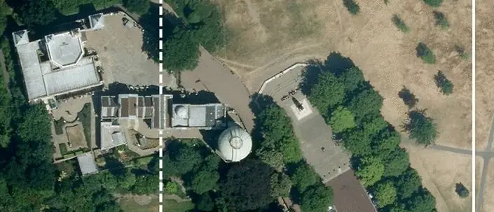
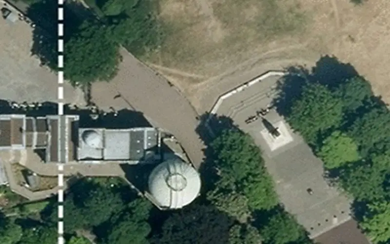
Royal Observatory of Greenwich. The Airy meridian (dotted line) and the ITRF zero meridian (solid line). Imagery 2014 Google Maps, Infoterra Ltd & Bluesky
Methods of determining longitude and Earth rotation
Traditional optical instruments for measuring Earth rotation included visual and photographic zenith tubes, circumzenithal, Danjon astrolabes, and transit telescopes, such as the Airy Transit Circle. These instruments measured local sidereal time by the passage of specially designated “clock stars” across a plane of reference established in part by the local direction of gravity. These measurements were realized with respect to the local vertical using a basin of mercury, and the astronomical latitudes and longitudes of the observatories were thus affected by local gravity, because their coordinates were determined from the same observations.
The sidereal time observed from these instruments was converted to mean solar time according to a conventional relationship, and time signals were adjusted to match the astronomical observations. The difference between astronomically determined local mean times t (in hours) is proportional to the difference in local longitudes (in degrees).
Because of significant discrepancies between the earliest radio time-signal broadcasts, the Bureau International de l’Heure (BIH) was established at the Paris Observatory in 1912 to help coordinate the national time bureaus and improve longitudes globally. For purposes of global timekeeping by the BIH, the Greenwich Observatory was superseded in 1929 by a statistical construct known as the “mean observatory”, of which Greenwich became one of many contributors. The formation of GMT, now called Universal Time, from this “mean observatory” involved adopted corrections to the contributed data and weights that could change annually. To maintain a continuous and consistent series of Universal Time, the BIH also assumed the responsibility for establishing and refining the terrestrial reference systems used for the analyses. The early BIH terrestrial reference frames were entirely based on astronomical coordinates.
Delays in the analysis of polar motion from the International Latitude Service (ILS) made it impractical for the BIH to correct Universal Time for the motion of the rotational pole until the middle of the twentieth century. Universal Time observed from a given observatory was designated UT0, whereas the distributed astronomical time scale corrected for polar motion became known as UT1. After the BIH adopted various reference poles of different epochs during the 1950s and 1960s, the BIH standardized on the average ILS pole from 1900–1905—known as the Conventional International Origin—as part of an update to celestial and terrestrial reference systems. To preserve the continuity of UT1–UT0 for contributing stations within this new “1968 BIH System”, the adopted longitudes of observatories were systematically adjusted for the change of pole. Although the Airy Transit Circle was no longer operational as a BIH station, its astronomical longitude would have changed from zero to 0.2927′′W (about 6 m) within this new system.
Since the 1960s, realizations of zero longitude from space-geodetic reference systems have tended to be east of the Airy Transit Circle by an amount that is close to the vertical deflection at Greenwich. This offset is mostly a consequence of artificial-satellite operations requiring the plane for the origin for UT1 to pass through the center of mass of the Earth (Fig. 2).
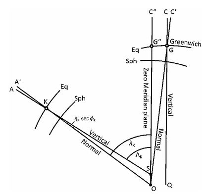
The reference ellipsoid from a point on its minor axis above the north pole. O = spheroid axis passing through the geocenter, Eq = ground level equipotential surface, Sph = spheroidal parallels, OA ′= geodetic meridian plane at K, SA = astronomical meridian plane at K (Bomford 1980)
In 1969, Gebel and Matthews observed a longitude difference of 5.64′′ between the Airy Transit Circle and zero longitude of the TRANSIT navigation system; at the time, it was conjectured that DoV at Greenwich contributed to the offset. Relative to the BIH origin for UT1, TRANSIT’s zero longitude was further assumed to be “quite close, i.e., about 1′′ apart, based on certain reasonable assumptions”, although the details behind this assessment were not published. This proximity was simply fortuitous: the original longitude reference for TRANSIT’s datum was implicitly defined by a regional NAD 27 survey of the TRANSIT antenna site (APLMND) at Applied Physics Laboratory (APL), in Laurel, Maryland, USA, where the longitude difference between NAD 27 and WGS 84 in the vicinity of the APL is about 1.2′′, as estimated by the authors. Later, Dillon et al. (1977) adjusted the TRANSIT station network to improve compatibility with WGS 72.
The authors have also identified one internet article (Mautz 2004) suggesting DoV as a probable source for the offset observed with GPS from Airy’s meridian line.
Conclusion
Zero longitude is the terrestrial origin for Universal Time (UT1), a realization of mean solar time at Greenwich used to define the rotation angle of the Earth in space. The 102-m offset between the Airy Transit Circle and zero longitude indicated by a GNSS receiver is attributable to the fact that continuity in the UT1 time series was maintained in the BIH reference frames, as geodetic longitudes replaced astronomical longitudes when space-geodetic methods were introduced. This continuity condition constrained the BTS 84, and consequentially, the ITRF zero meridian plane, to be practically parallel to the orientation of the astronomical prime meridian through Airy’s instrument that is aligned to local gravity. Extended to infinity, these parallel meridian planes sweep past the same stars simultaneously, so that both planes indicate the same astronomical time (UT1). The difference between precise GNSS coordinates and astronomically determined coordinates everywhere remains a localized gravity effect due to the deflection of the vertical; thus, no systematic rotation of global longitudes occurred between the former astronomical system and the current geodetic system.
Because the value of the DoV at Greenwich and the continuity constraint on UT1 were the primary factors that influenced the current location of the ITRF zero meridian, the 1884 recommendation of a prime meridian based on the “Observatory in Greenwich” has been practically maintained to the present by passing the zero meridian plane through the center of mass of the Earth, rather than through the center of the Airy Transit Circle. Modern, high-resolution global gravitational models of the Earth confirm that the local slope of the geoid at Greenwich is of the proper sign and magnitude to support this interpretation, conclusive to within the accuracy of the deflection model (±0.5′′ 1 σ in longitude for the EGM2008 model).
Reference: Stephen Malys et al.: Journal of Geodesy Continuation of Bulletin Géodésique and manuscripta geodaetica 2015:844