Airborne Snow Observatories, Inc. Takes Delivery of the All-New Cutting-Edge RIEGL VQ-1560 II-S LiDAR System
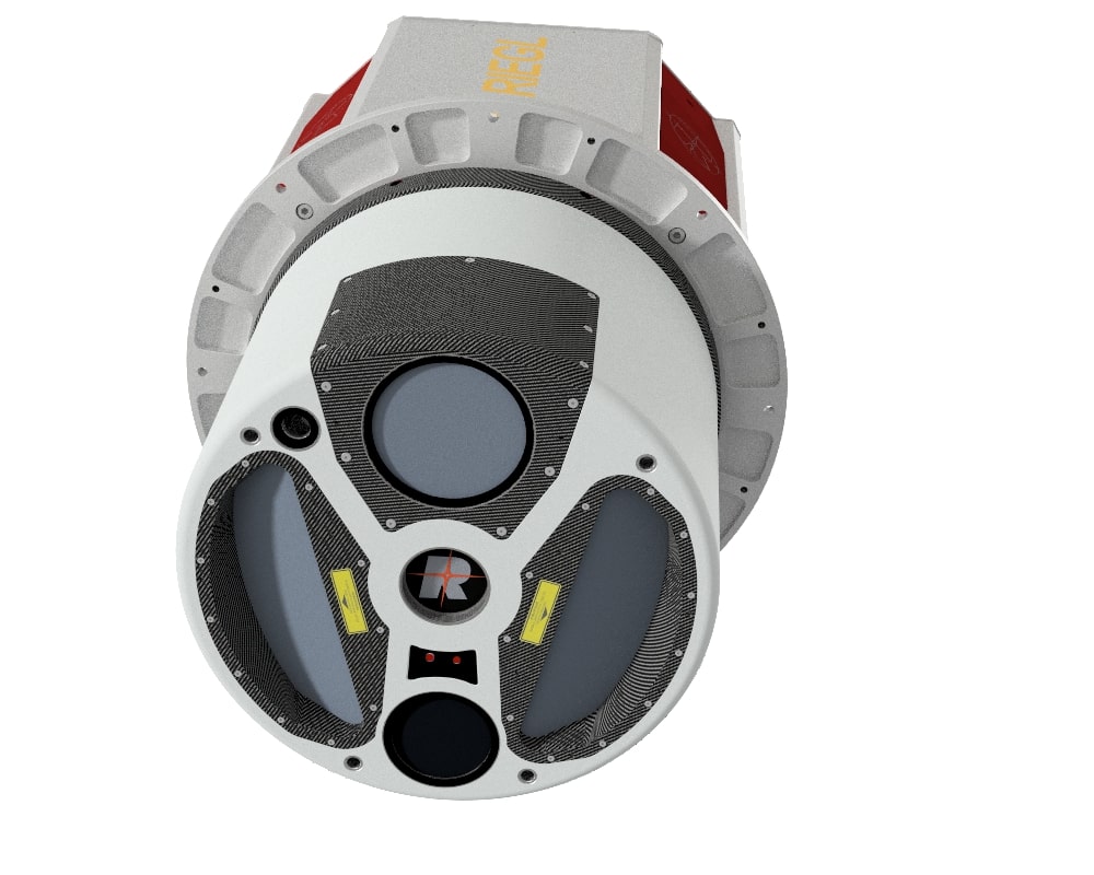
Airborne Snow Observatories, Inc. has just taken delivery of one of the first in North America cutting-edge RIEGL VQ-1560 II-S airborne laser scanners, just as the ASO program at NASA pioneered the use of the first of RIEGL’s dual laser scanner, the LMS-Q1560 in 2013. This new LiDAR system, with its doubled laser power and high pulse frequency, will allow ASO Inc. to far more efficiently achieve its needs to uniquely measure snow water equivalent across extensive mountain basins.
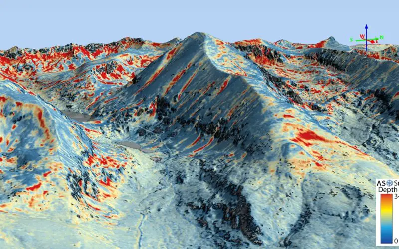
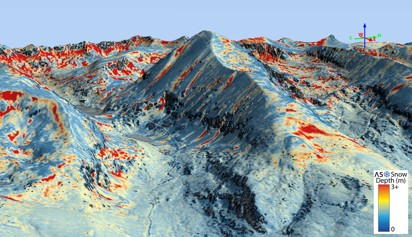
ASO Inc. is a public benefit corporation that was created via technology transfer from the NASA Jet Propulsion Laboratory to continue and expand ASO operational snow mapping and runoff forecasting to the world’s mountains. Through coupling of RIEGL LIDAR, imaging spectrometer data, and physical modeling, ASO Inc. maps mountain snow depth, snow water equivalent, and snow albedo. This is accomplished with unrivaled accuracy and coverage, enabling reliably high accuracy streamflow forecasting for water management agencies, irrigation districts, and municipalities. With a changing climate, intense droughts such as that currently impacting the Western US, and increased demands on water resources, these paradigm-shifting measurements and forecasts are critical for modern resource resilience.
The ASO program already pushed its capabilities to map series of mountain basins on the RIEGL LMS-Q1560. Now, the greater capabilities of the VQ-1560 II-S are enabling ASO Inc. to optimize collections at higher flight altitudes over rough terrain and in tight weather windows while maintaining high point densities and surface detection over highly varying target ranges and forest cover densities. The new VQ-1560 II-S follows the successful concept of RIEGL’s proven Dual Channel Waveform Processing LiDAR Scanning Systems, now with increased laser power for ultra-wide area mapping. The VQ-1560 II-S is the latest model of maximum-productivity airborne laser scanning systems available from RIEGL for large, state-wide collection initiatives, urban mapping programs and/or corridor asset surveying. With increased laser power, the operational altitudes are extended, and these improved maximum ranges allow an increase of the system’s productivity.
RIEGL USA Senior Vice President, James Van Rens said “Water is one of the most important resources on earth. ASO’s high accuracy and high-density spatial variability of snow water equivalent is critical to water management districts, particularly in the western U.S. RIEGL is proud to be a partner with ASO and their important mission.”
“The advances made by RIEGL from the LMS-Q1560 to now the VQ-1560 II-S have made possible the uniquely intense acquisitions by ASO Inc. over high mountains,” said Thomas Painter, ASO Inc. Chief Executive Officer and Founder. “We are compelled to cover large snow-covered mountain areas in short weather windows with high accuracy and precision. With the VQ-1560 II-S, we have greater acquisition efficiencies at higher altitudes, and we are still penetrating forest canopies to underlying snow at large ranges.”
RIEGL is committed to delivering proven innovations in 3D and dedicated to designing, developing, and producing the best possible laser sensors for the desired application in order to perfectly fulfil the given measurement task.
RIEGL is thrilled that long-time customer, ASO Inc., has chosen the new and innovative RIEGL VQ-1560 II-S to assist with their project productivity and innovative product development.
About ASO Inc.
ASO Inc. is the unique international provider of accurate snow product mapping and runoff forecasting with airborne lidar and imaging spectrometer remote sensing and physical modeling, based in the Sierra Nevada of California. The Airborne Snow Observatory program began as a research and applied research mission at the NASA Jet Propulsion Laboratory for nearly a decade, achieving enormous successes such as the first complete remote sensing of mountain snow water equivalent and marked improvements in streamflow forecasting. Its unique lidar acquisitions, optimized mountain flying, rapid product turnaround, and rapid model assimilation established its market and have set the stage for innovations in the remote sensing/geospatial industry. ASO Inc. was formed with the core team as a public-benefit corporation to perform the technology transfer of the ASO program to a global implementation.
About RIEGL
RIEGL is an international leading provider of cutting-edge technology in airborne, mobile, terrestrial, industrial and unmanned laser scanning solutions for applications in surveying. RIEGL has been producing LiDAR systems commercially for over 40 years and focuses on pulsed time-of-flight laser radar technology in multiple wavelengths. RIEGL’s core Smart-Waveform technologies provide pure digital LiDAR signal processing, unique methodologies for resolving range ambiguities, multiple targets per laser shots, optimum distribution of measurements, calibrated amplitudes and reflectance estimates, as well as the seamless integration and calibration of systems. RIEGL’s Ultimate LiDARTM 3D scanners offer a wide array of performance characteristics and serve as a platform for continuing Innovation in 3D for the LiDAR industry. From the first inquiry, to purchase and integration of the system, as well as training and support, RIEGL maintains an outstanding history of reliability and support to their customers. Worldwide sales, training, support and services are delivered from RIEGL’s headquarters in Austria; main offices in the USA, Japan, China, Australia, Canada and the UK; and a worldwide network of representatives.
Also Read –