
Tag "U.S. Geological Survey"
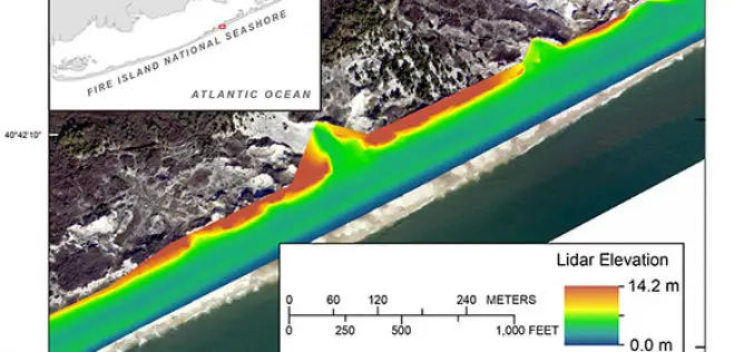
Terrestrial-based Lidar Beach Topography of Fire Island, New York
Abstract: The U.S. Geological Survey (USGS) St. Petersburg Coastal and Marine Science Center (SPCMSC) in Florida and the USGS Lower Mississippi-Gulf Water Science Center (LMG WSC) in Montgomery, Alabama, collaborated to
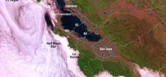
New California Fog Maps Reveal Pictures for Planning
A new series of maps of fog and low clouds covering the northern and central California coasts reveals daytime and nighttime patterns with a level of detail never previously mapped.

USGS Increases Public Access to Scientific Research
The U.S. Geological Survey is implementing new measures that will improve public access to USGS-funded science as detailed in its new public access plan. The plan enables the USGS to

Low-Level Flights in Southeast Missouri Will Look at Geology and Mineral Resources
A high-resolution airborne survey to study the rocks within the St. Francois Mountains will be conducted by U.S. Geological Survey scientists starting this week. Over the next month, an airplane
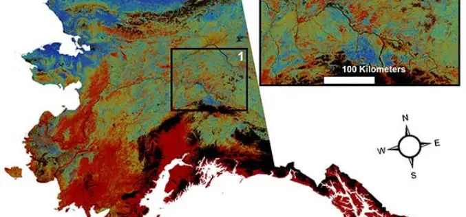
USGS Projects Large Loss of Alaska Permafrost by 2100
Using statistically modeled maps drawn from satellite data and other sources, U.S. Geological Survey scientists have projected that the near-surface permafrost that presently underlies 38 percent of boreal and arctic

Joint Venture, U.S. Geological Survey Join Forces
Partnership to Tackle Earth and Atmosphere Challenges to Silicon Valley Joint Venture Silicon Valley and the U.S. Geological Survey today jointly announced a partnership to address regional challenges from natural
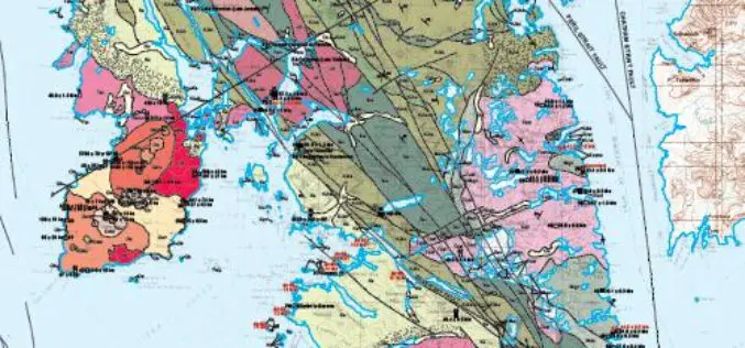
Geologic Map of Baranof Island, Southeastern Alaska Now Online
Alaska — In the 20th century, Baranof Island in Southeastern Alaska has drawn attention for its gold, chrome and nickel deposits, timber industry, potential activity of the dormant Mount Edgecumbe

A New Era of Space Collaboration between Australia and U.S.
On June 18, 2015 in Canberra, Australia, the U.S. Geological Survey and Geoscience Australia signed a comprehensive new partnership to maximize land remote sensing operations and data that can help

USGS Ups Ease of Use for Landsat Data
Landsat satellite data have been produced, archived, and distributed by the U.S. Geological Survey since 1972. Data users in many different fields depend on this basic Earth observation information to
USGS Continues to Write History
New Volume of Agency Annals Released The fourth volume of the comprehensive history of the U.S. Geological Survey, Minerals, Lands, and Geology for the Common Defence and General Welfare: Volume
