
Tag "Satellite imagery"
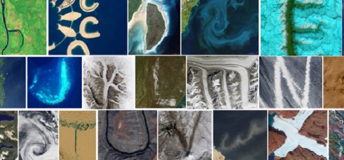
Reading the ABCs from Space
Contributed By:- Space and space-based technologies offer significant and unique solutions to many of real-world problems through remote monitoring and accessing information. Revolution in Earth observations from space has fueled by
PHOTOMOD Technical Seminar in Agra, India – Limited Offer
PHOTOMOD technical seminar will take place on November 16 (Wednesday). This free seminar provides a forum for professionals working in the field of photogrammetry and covers topics related to increasing
Release of PlanetSAT 15 L8 imagery Basemap of Asia by PlanetObserver
Clermont-Ferrand, 12 October 2016 – The French company PlanetObserver, specialized in imagery basemap production for more than 25 years, announced today the coverage of Asia with PlanetSAT 15 L8 basemap,

DigitalGlobe’s Basemap Suite Expands to Include 250 Million Square Kilometers of 30 cm Imagery
More than 500 population centers now feature the world’s highest resolution commercial satellite imagery WESTMINSTER, Colo.–(BUSINESS WIRE)–Sep. 28, 2016– DigitalGlobe, Inc. (NYSE: DGI), the global leader in Earth imagery and

Airbus Defence and Space Invests in Very High-Resolution Satellite Imagery from 2020 Onwards
-Four very high-resolution (VHR) optical Earth observation satellites to be launched in 2020 and 2021 will ensure continuity of Pléiades misión – Highly responsive dual VHR constellation will offer state-of-the-art
Airbus Defence and Space Launches “One Tasking”, Defining a New Level of Customer Centric Services for Satellite imagery Acquisition and Delivery
Airbus Defence and Space launched its latest development in satellite imagery acquisition and distribution, One Tasking. Representing a major step change, One Tasking offers customers the most intuitive and cost-effective
NMDC Inks MoU with ISRO for Mineral Mapping
In a bid to make use of satellite-based geological mapping capability for mineral exploration, National Mineral Development Corporation (NMDC) has signed a memorandum of understanding (MoU) with Indian Space Research

Railway Land Management Module to Tackle Encroachment Menace
Railways have developed a web-based application called Land Management Module to provide the status of rail land whether encroached or not which would be helpful in tackling the menace of

Vricon and Japan Space Imaging Partner on Bringing High-res 3D and Elevation Geodata Products to Japan
McLean, VA – 6 April 2016 —Vricon has announced it has selected Japan Space Imaging Corporation (JSI) for an exclusive reselling agreement. JSI is appointed as Vricon’s distributor in Japan
Hera Systems Unveils Groundbreaking $1 Pricing for Satellite Imagery
Simple Pricing Ranges from $1-$3 for Archived and Freshly Tasked High-Resolution Imagery SAN JOSE, Calif. – Hera Systems has unveiled the industry’s most aggressive, simplest pricing for high-resolution satellite imagery
