
Tag "press release"
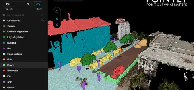
Pointly – Next Level 3D Point Cloud Classification Tool Launched
Supper & Supper has launched Pointly, the solution enabling accelerated manual 3D point cloud classification using innovative AI techniques.

EagleView Announces Gold Status within Esri Partner Network
EagleView Technology Corporation, a leading technology provider of aerial imagery, data analytics and GIS solutions, announced that its wholly owned subsidiary, Pictometry International Corp., has obtained gold status within the

Esri and European Schoolnet Partner to Deliver Geographic Education Internationally
More Than 30 Ministries of Education to Gain Access to ArcGIS Online Redlands, California—School systems across Europe will soon have access to the world’s leading online mapping software for delivering

Spymesat Mobile App Now Offers High Resolution Satellite Imagery
Orbit Logic announced today that the iPhone version of their SpyMeSat mobile app will now offer in-app purchase of recent high resolution satellite imagery. SpyMeSat users will be able to use their

LocationSmart Issued Patent for Location-Based Dynamic Status Reporting
New Patent Bolsters Core Focus in Location Intelligence Carlsbad, CA, June 26, 2014 LocationSmart®, the leading provider of cloud-based location and interactivity services, has announced the issuance of US Patent 8,666,373 by the

Global GIS Market in the Utility Sector 2014-2018
United States FOR IMMEDIATE RELEASE, Illinois – United States – June 24,2014 (PR Carbon): Global GIS Market in the Utility Sector 2014-2018 is a new market research publication announced by Reportstack. A
