
Tag "Ordnance Survey"

Ordnance Survey Acquire Shareholding in Dennis Maps
Ordnance Survey (OS) and Dennis Maps have signed an agreement for Britain’s mapping agency to acquire a 25% The new partnership builds on the relationship between the two organisations which commenced
Manchester Wins £10m Prize to Become World Leader in ‘Smart City’ Technology
Ordnance Survey is part of a public – private consortium that is celebrating winning a £10m competition for Manchester to be the UK’s Internet of Things (IoT) Demonstrator, awarded by the

Geovation Water Challenge Launches
Funding for innovation that improves our relationship with water. Ordnance Survey’s ninth Geovation® Challenge launched on 1 December, and sees Britain’s mapping agency offering development funding and places on its Geovation

Join OS Experts for a Beginner’s Guide to Map Reading
Ordnance Survey adventurers will be at Cotswolds Outdoors across the country giving free map reading lessons. The workshop is for beginners and aims to give them the confidence to better explore

Ordnance Survey and Hexagon Geospatial Partner to Develop Information Services
Combining the Hexagon Smart M.App® with Ordnance Survey’s expertise, content and services will support key initiatives in Britain and abroad Ordnance Survey and Hexagon Geospatial are pleased to announce a new partnership,
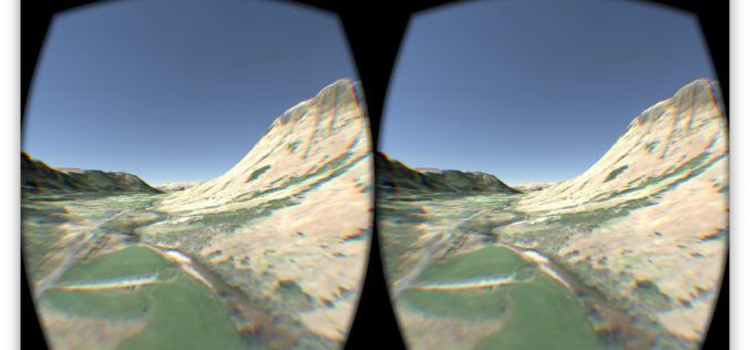
OS Data Gives Reality to a Virtual World
OS follows up its Minecraft map success to make a virtual Ben Nevis for Oculus and cardboard. The spectacular setting of Ben Nevis provides the backdrop for an Oculus Rift
Digimap for Schools Launches 1950s Maps of Great Britain
Digimap for Schools now has a second historic map layer added to its popular online service, giving teachers and pupils direct access to Ordnance Survey mapping from three centuries. Covering the

Ordnance Survey Selects SimActive’s Correlator3D
SimActive Inc., a world-leading developer of photogrammetry software, is pleased to announce the purchase of Correlator3D licenses by Ordnance Survey, the UK government agency responsible for mapping. Ordnance Survey had
Escape the Obvious With the Ordnance Survey Graduate Scheme
Ordnance Survey graduate recruitment scheme for 2016 has launched, offering graduates the opportunity to lead the way on developing innovative and inspirational solutions for digital data. Ordnance Survey is looking for talented,
Ceremonial and Historic County Boundary Data added to OS OpenData Portal
For 224 years Ordnance Survey (OS) has been mapping the changing physical landscape of Great Britain. However it is not only the landscape which has changed, Great Britain’s county boundaries have also changed
