
Tag "Ordnance Survey"
UK Announces New Geospatial Commission
Chancellor announces new Geospatial Commission to maximise the value of all UK government data linked to location. UK – November 22, 2017 – The Chancellor has announced today a new Geospatial

Geovation Programme Now Open to Location and Land Disruptors
The Geovation Programme is now accepting applications from start-ups using location and/or land and property data in their products and services. 01 August 2017 – A new generation of location
Blue Marble Releases Geographic Calculator 2017 with New Quality Control Tool for Seismic Survey Data
Hallowell, Maine – April 18, 2017 – Blue Marble Geographics (bluemarblegeo.com) is pleased to announce the immediate availability of Geographic Calculator 2017. This major version release introduces a new job
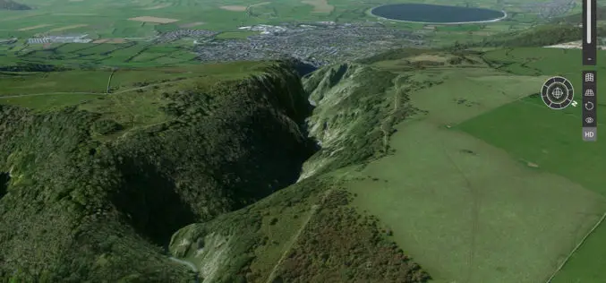
Explore Great Britain with OS’s Ultimate Adventure Planning Tool
Fresh from being named the UK Outdoor Industry’s Digital Product of the Year, OS Maps has become even better with the inclusion of an immersive 3D view of Great Britain in

Trimble and Ordnance Survey Collaborate to Aid Geospatial Industry Innovation
An exciting new relationship between Trimble and Ordnance Survey (OS) sees innovators at the Geovation Hub leverage Trimble’s latest technologies. Innovators at Ordnance Survey’s Geovation Hub, a group ranging from Big Data

OGC Invites Expertise on Underground Maps and Models
February 13, 2017: The Open Geospatial Consortium (OGC®) is requesting information from interested parties to inform a Concept Development Study (CDS) that will assess the current state and future direction

Ordnance Survey International Helps the UAE Manage Climate Change
Ordnance Survey International and Deimos Space UK are to work with the Mohammed bin Rashid Space Centre in Dubai to help the United Arab Emirates (UAE) improve how it plans and

Ordnance Survey’s Ground Breaking Planning and Mapping Tool for the National Rollout of 5G Technology
The holly and the 5G Bournemouth’s Christmas tree, lights and decorations feature in Ordnance Survey’s ground breaking planning and mapping tool for the national rollout of 5G technology. Bournemouth’s Christmas tree,

UK Leading the Way to a 5G Future
World first initiative will lay groundwork for a hyper-connected Britain. Ordnance Survey to create UK’s digital twin – a smart map for a smart future. Project will cement UK’s position as
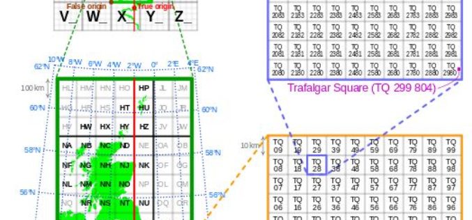
Is Britain on the move?
Australia has recently announced a 1.8m shift in its mapping coordinates, to compensate for the country’s 7.5cm shift north each year. Inevitably the question is why, and could the same
