
Tag "mapping"
Calspan Invests in the Future of Drone Technology
Adding another aircraft to an ever-growing fleet allows Calspan to better address the needs of an evolving customer base. Buffalo, New York – October 31, 2017 – Calspan is pleased to

SimActive Automates Direct Georeferencing
October 31, 2017 – SimActive is pleased to announce an automated solution for direct georeferencing from real-time kinematic (RTK) positioning. Within the new workflow feature, users can easily get high accuracy
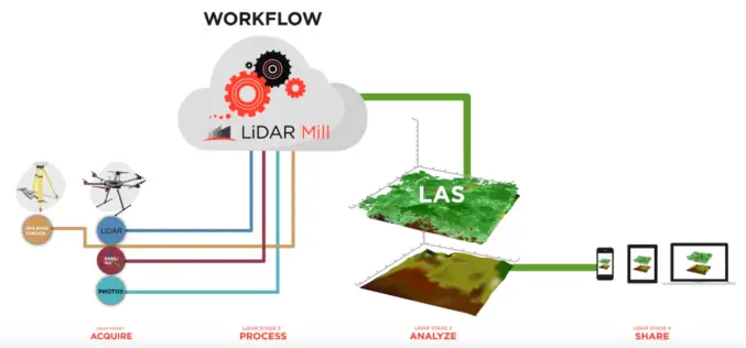
Phoenix LiDAR Unveils LiDAR Mill, the First Cloud-Based Post-Processing Platform
Cloud-based LiDAR platform automates trajectory processing, making the technology more affordable and accessible LOS ANGELES, CA (PRWEB) OCTOBER 26, 2017 – Addressing a major opportunity in the LiDAR industry, Phoenix LiDAR Systems

Velodyne LiDAR Partners with YellowScan for Integrated LiDAR for UAVs
YellowScan to leverage Velodyne’s lightweight VLP-16 Puck LiDAR sensors for its advanced aerial Surveyor LiDAR system October 26, 2017 – SAN JOSE, Calif.–(BUSINESS WIRE)–Velodyne LiDAR Inc., the world leader in 3D
NavVis Partners with PrecisionPoint to Bring the American Indoors Online
13 October 2017 – NavVis, the global leader in indoor mapping, visualization, and navigation, announces a new partnership with PrecisionPoint, a leading reality capture solutions provider in the USA. PrecisionPoint is

GeoSLAM and Bentley Systems Join Forces to Take Mobile Reality Modelling Indoors
BENTLEY YII 2017, SINGAPORE, OCTOBER 5, 2017 – GeoSLAM – the experts in “go anywhere” 3D mobile mapping technology, and Bentley Systems, a leading global provider of comprehensive software solutions for advancing infrastructure,
SimActive Announce the Release of Correlator3D™ version 7.0
SimActive Inc., is pleased to announce the release of Correlator3D™ version 7.0, with complete redesign of its 3D generation engine enabling substantial quality and speed improvements. Version 7.0 also includes

Geospatial Technology to Support National Mission for Clean Ganga
September 29, 2017 – New Delhi – (IANS) – Union minister of state for Water Resources, River Development and Ganga Rejuvenation Satyapal Singh on Thursday asked the officials of National Mission
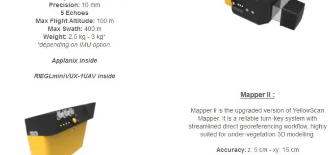
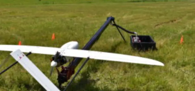
YellowScan Unveils Its Next Generation UAV-LiDAR Systems
Montpellier, 21 September 2017 – YellowScan is committed to provide the most reliable integrated imaging systems and customer support for demanding UAV applications. Since 2012, the team’s dedication to fulfill high resolution and high-quality survey
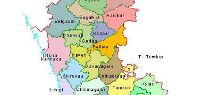
12 Taluks of Karnataka to get Soil Condition Map
According to recent news by The Hindu Business Line, the National Bureau of Soil Survey and Land Use Planning (NBSSLUP) is working on a project to map soil in 12
