
Tag "mapping"
Orbit GT Releases 3D Mapping Feature Extraction Pro V18.0.6
March 19, 2018 – “We’re proud to announce that, with this release, our full portfolio has now been upgraded to version 18”, says Peter Bonne, CEO of Orbit GT. “As

Trimble Announces Call for Speakers for its 2018 Dimensions International User Conference
SUNNYVALE, Calif., March 13, 2018—Trimble (NASDAQ:TRMB) has opened its Call for Speakers for the 2018 Trimble Dimensions International User Conference, which will be held November 5-7 at The Venetian in
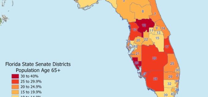
Maptitude 2018 USA Legislative and Congressional Districts
NEWTON, MASSACHUSETTS (USA) – Caliper is pleased to announce that the State Legislative Districts Data Product is now available for the entire USA or for a single US state. Three area databases

Tata Power Delhi Distribution Ltd Implemented GPS Mapping Technology for Speedy Location and Repair of Faults
According to recent news reported by the Energy World, in a first for India, Tata Power Delhi Distribution Ltd (TPDDL) has implemented GPS mapping and Radio Frequency Identification Detector (RFID) Marker installation
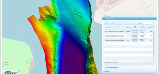
Real-time Mapping and Visualization in CARIS Onboard 2.0
Fredericton, NB, Canada – March 06, 2018 – Teledyne CARIS™ is pleased to announce the release of CARIS Onboard™ 2.0. CARIS Onboard enables users to apply processes automatically to their data in

Bangalore Started Rooftop Solar Energy Potential Mapping Using Aerial LiDAR
According to recent news reported by The Hindu, Over the fortnight, a helicopter armed with LiDAR system will fly across the city, mapping its potential to generate rooftop solar energy. The

DroneDeploy Launches Real-Time Mapping for Instant Aerial Data and Analysis
Live Map Creates Instant Drone Maps on iOS Devices, Allowing Decision-Makers to Take Immediate Action SAN FRANCISCO – February 15, 2018 – (BUSINESS WIRE)–DroneDeploy, the leading drone mapping software platform in the
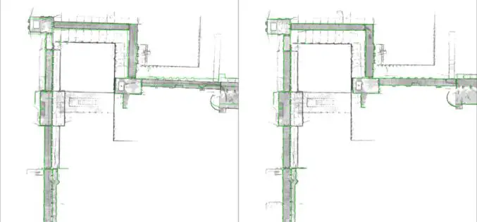
NavVis Sets New Standard in SLAM Precision
New algorithm reduces drift error in indoor environments MUNICH, Germany, 7 February 2018 – NavVis, a global leader in mobile indoor mapping, visualization, and navigation, announces new mapping software that significantly improves the

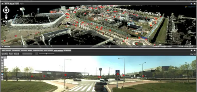
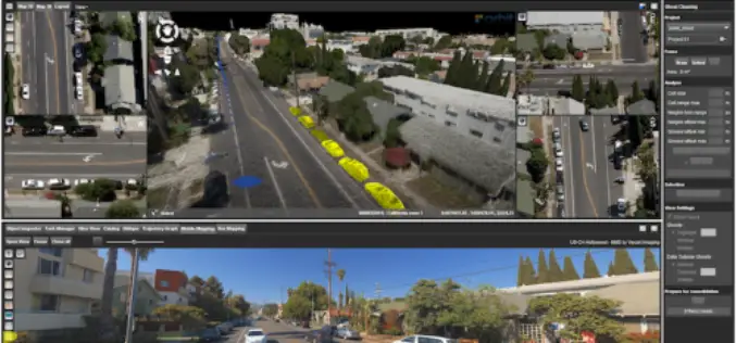
Leica Geosystems Multipurpose Mobile Mapping Platform Increases Smart City Applications
Leica Pegasus:Two Ultimate enables professional 360-degree seamless imagery Heerbrugg, Switzerland, February 06, 2018 – Leica Geosystems, industry leader of measurement technology, released today the new Leica Pegasus:Two Ultimate, an upgrade to
Orbit GT Releases 3D Mapping Content Manager V18
Jan. 30, 2018 – Orbit GT is happy to release the new 3D Mapping Content Manager v18. “The Content Manager is arguably the most unique yet extremely powerful product in our
