
Tag "ISRO"
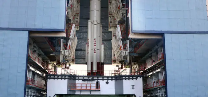
Isro to Launch Cartosat-2 Series Satellite Mission : Scheduled on June 22, 2016
India’s Polar Satellite Launch Vehicle, in its thirty sixth flight (PSLV-C34), will launch the 727.5 kg Cartosat-2 series satellite for earth observation and 19 co-passenger satellites together weighing about 560 kg
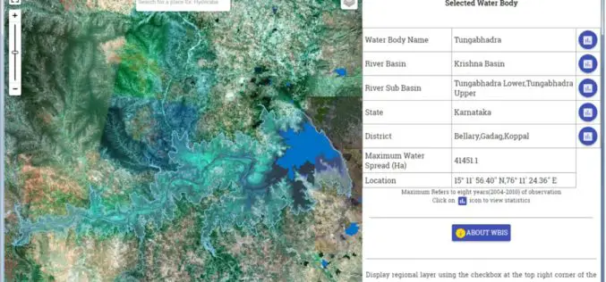
Temporal Repetitive Mapping of Water Bodies Across India
National Remote Sensing Centre (NRSC), ISRO at Hyderabad monitors the status of all the water bodies in the country using satellite images and provides water spread area information on a

“India Should Build Its Own Space Station”
India should actively get into building its own space station in the Low Earth Orbit (LEO) as its next space frontier since the time is opportune for this, a retired
NMDC Inks MoU with ISRO for Mineral Mapping
In a bid to make use of satellite-based geological mapping capability for mineral exploration, National Mineral Development Corporation (NMDC) has signed a memorandum of understanding (MoU) with Indian Space Research

Satellite Reveals Decline in the Number of Forest Fires in Uttarakhand
According to recent news by The Hindu, Satellite images show that there’s been a decline in the number of forest fires in Uttarakhand since April 28. Though fires in the
Punjab Government to Utilise Remote Sensing Satellites for Development
Punjab government on Monday said India should make use of its remote sensing satellites more efficiently for development in agriculture and rural and urban planning. “India, having the largest constellation
Cartosat-2C to Boost Military Surveillance
According to recent news by The Indian Express, ISRO’s earth observation satellite Cartosat-2C will be launched in May using a PSLV rocket. It will prove to be a shot-in-the-arm for India’s
ISRO to Monitor Water Bodies in Tribal Areas Using Geospatial Technology
New Delhi – In a first, ISRO’s National Remote Sensing Centre (NRSC) will monitor and map the water bodies in tribal belts in the country to help tackle irrigation crisis
ISRO, Indian Railways to Sign MoU Over Remote Sensing and GIS
NEW DELHI: Aiming at effective use of space technology in remote sensing and graphic information system (GIS) based applications, Railways is set to join hands with Indian Space Research Organisation
ISRO to Double Missions to 12 Per Year
Having launched 55 missions in space in the last five years, the national space agency ISRO is looking at doubling the number of missions in the next five years to
