
Tag "GIS data"

RAMTeCH Optimizes GIS Data Quality with gReady
RAMTeCH Software Solutions, Inc., a global leader in spatial enterprise solutions, introduces its gReady™ data quality analytics software solution to help uncover, prioritize and correct operational data quality errors in Geographic Information
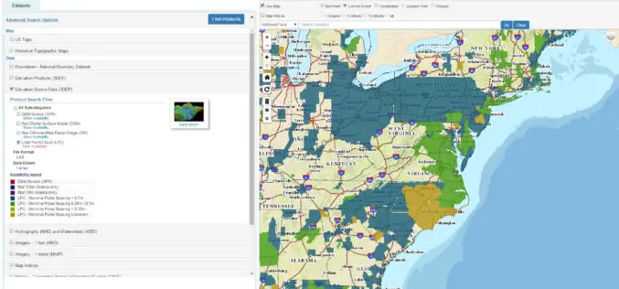
The National Map Data Download Enhancements
The USGS National Map program is transitioning all of its GIS data download capabilities to its new TNM Download client during the week of February 15, 2016. The new launch
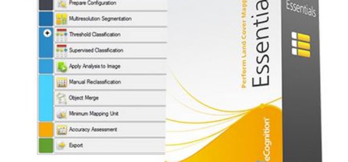
How to automatically update your Vector GIS Data using Trimble eCognition
Webinar: How to automatically update your Vector GIS Data using Trimble eCognition Tue, Feb 16, 2016 9:30 PM – 10:30 PM IST Show in My Time Zone Our GIS databases

New Leica ULTRA Locator: Best Accuracy Results in Faster, More Confident Work
Outstanding performance with operational ease and flexibility help users attain the highest accuracy to avoid costly mistakes, such as cutting utility lines or delaying project schedules during excavation work. By
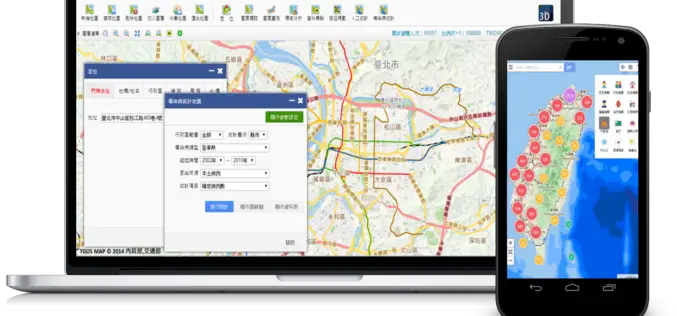
Geospatial Data in Taiwan – Focus on Integration
Supergeo’s biggest application customer in Taiwan, Ministry of the Interior and the TGOS platform, has just announced one of the biggest projects in the GIS field from ide@ Taiwan 2020

Successful Launch for interaerial SOLUTIONS
Karlsruhe, 6 October 2015 – The interaerial SOLUTIONS communications platform premiered at INTERGEO 2015 in Stuttgart really took off with exhibitors and visitors alike. Unmanned aircraft system (UAS) manufacturers and

French Energy Company SPIE chooses SuperPad To Enhance Survey Efficiency
Supergeo, the total GIS software solution provider, announces that SPIE, France, chooses SuperPad, the mapping application designed for Windows Mobile,to empower its streetlights and other utilities survey works. SPIE, the
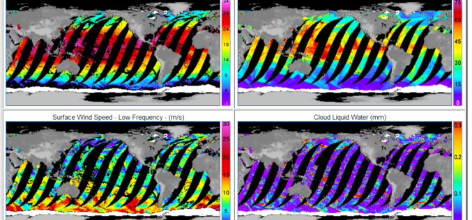
GPM Microwave Imager Data Products are Now Available to Download
Remote Sensing Systems has just released the GPM Microwave Imager (GMI) ocean product suite. The Global Precipitation Measurement (GPM) satellite has a microwave radiometer onboard called GMI (GPM Microwave Imager). The

SuperField Supports Portuguese GPS Provider with GIS Application
Nautel, Portugal, the navigation and GPS turnkey solution provider, selects SuperField, the GIS data collection application, to provide users with a complete survey task-oriented choice. Founded in 1990, the Lisbon-based

Esri Publishes Getting to Know ArcGIS, Fourth Edition
Use the Workbook and Exercises to Get Started Making Maps and Analyzing Data Learn the fundamentals of making digital maps, analyzing geospatial data, and building and editing spatial databases using
