
Tag "GIS application"

W3C and OGC to Collaborate to Integrate Spatial Data on the Web
6 January 2015 — The W3C and the Open Geospatial Consortium (OGC) announced today a new collaboration to improve interoperability and integration of spatial data on the Web. Spatial data

iLOOKABOUT Corp. Announces Conversion of Unpaid Dividends to Common Shares
LONDON, ON–(Marketwired – January 02, 2015) – iLOOKABOUT Corp. (TSX VENTURE: ILA) (“iLOOKABOUT” or “the Company”) announced today that, subject to the approval of the TSX Venture Exchange, the Company
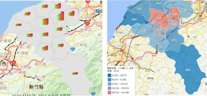
Statistics Map APIs Service Platform
Displaying statistical data on map extends GIS applications to more domains, as it is much easier and more informative for researchers to comprehend meanings of the data through its intuitive

ThinkGeo Releases Map Suite for Android, iOS and WebAPI
Frisco, TX — ThinkGeo is proud to announce the additions of Map Suite WebAPI , Map Suite for Android and iOS platforms to the Map Suite family of products. These
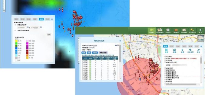
GIS-powered Vector Mosquito Data Management System to Enhance Public Health
In warm and humid subtropical areas like Southeast Asia, prevention and cure of vector mosquito is a key mission for epidemic and diseases control authorities. To achieve the goal, officers

RFP for Establishment of an Enterprise GIS and GIS applications
Principal Chief Conservator of Forests (PCCF), Odisha, India Request for Proposal for Establishment of an Enterprise GIS and GIS applications in Forest Department , Government of Odisha. Reference No. – RFP

Chinese Democracy Supported by Geospatial Technologies
Since the 1997 Handover from United Kingdom to China, Hong Kong 1 July March has been the largest civil movement in HK. As the activity became more like a protest,

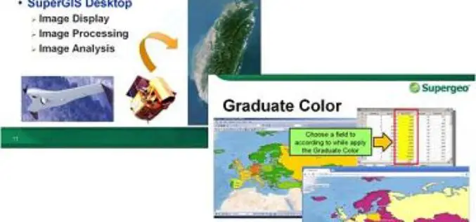
Philippine National Irrigation Systems Upgrades Parcel Maps by SuperGIS Desktop
Supergeo Technologies, a leading global provider of GIS software and solutions, announces that Philippines National Irrigation Systems (NIA) upgrades the country’s parcellary maps through SuperGIS Desktop to elevate the efficiency
Supergeo to Provide Free Online GIS Web Courses
To well promote GIS technologies in real case application, Supergeo is going to provide free online GIS web courses. From basic to advanced, the courses will introduce GIS software on
Dengue Fever Control and Prevention via GIS Technologies
Controlling and preventing infectious diseases like dengue fever is one of the main issues for public health authorities in many countries. GIS technologies can play a key role to support
