
Tag "Geoinformation"
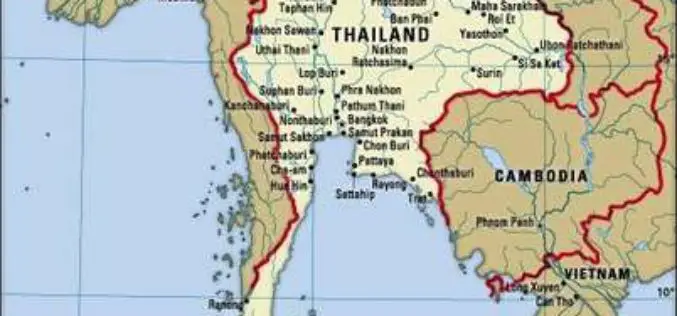
Airbus to Provide an End-to-end Geo-Information System to Thailand
Earth observation satellites, capacity building, integrated geo-information platform to support the Kingdom of Thailand’s key development priorities The Geo-Informatics and Space Technology Development Agency of Thailand (GISTDA) has selected Airbus

China Unveils Results of First National Geoinformation Survey
China boasts a total of 7.56 million square kilometers of vegetation cover, while buildings cover 153,000 square kilometers of land, the State Council Information Office unveiled at a news briefing
INTERGEO 2016 – Conference Programme Online
Karlsruhe, 16June 2016|“The topics being covered are as diverse as the geo community itself,” says Professor Karl-Friedrich Thöne, President of the DVW, describing the INTERGEO conference programme, which has just
INTERGEO 2016 – Key Topic: Smart City
Karlsruhe, 3 May 2016 | By taking “Smart City” as a key topic, INTERGEO 2016 is focussing on a multi-faceted issue that will shape the future. The preview of the

China’s Geoinformation Industry to Touch $6.6 Billion: Official
Beijing, Nov 10, 2015 – China’s geoinformation industry is booming with the output value expected to touch 360 billion yuan (USD 56.6 billion) this year, an increase of 22 per

Tell Your Story to Airbus Defence and Space and Win €500 GeoStore Voucher
Are you using Airbus Defence and Space products and solutions for sectors such as Defence and Intelligence, Oil & Gas, Emergency Response, Land Administration, Civil Engineering, Forestry & Environment, Agriculture
INTERGEO 2015 Ends Successful – Geo-Sector Agrees: Geoinformation is The International Language Of Decision-Makers
Stuttgart, 17 September 2015 – Geoinformation is the global language that decision-makers all understand. This places the geoinformation sector, with its technologies and solutions, in a key position to deliver

OGC Calls for Participation in GeoSemantics Summit
30 April 2015 – On 3 June 2015, the Open Geospatial Consortium (OGC) GeoSemantics Domain Working Group will host a summit, “GeoSemantics: Standards Intersect Ontologies”. This summit will be part
PhD in Air quality Mapping in Space and Time at ITC
The University of Twente. We stand for life sciences and technology. High tech and human touch. Education and research that matter. New technology which drives change, innovation and progress in
