
Tag "ESRI ArcGIS"

CompassCom to Release CompassTracker App for iOS & Windows Mobile Smart Phones at Esri User Conference
CENTENNIAL, Colorado, 6 July 2017 – CompassCom Software, developers of industry-leading Mobile Resource Management (MRM) solutions, will release CompassTracker for iOS and Windows Mobile at the 2017 Esri User Conference.

TerraGo Edge 4.0 Re-Imagines the User Experience, Adds New Mobile Features and Expands ESRI® ArcGIS® Integration Options
Using a customer-driven, agile feedback loop, TerraGo Edge undergoes a complete redesign, improves every aspect of the user experience to help get work done faster, easier and more efficiently than
DigitalGlobe Announces Launch of SecureWatch™, Advancing Mission Preparedness and Success When Decisions Matter Most
WESTMINSTER, Colo.–(BUSINESS WIRE)–Feb. 15, 2017– DigitalGlobe, Inc. (NYSE: DGI), the global leader in Earth imagery and information about our changing planet, today announced the launch of a new product, SecureWatch,

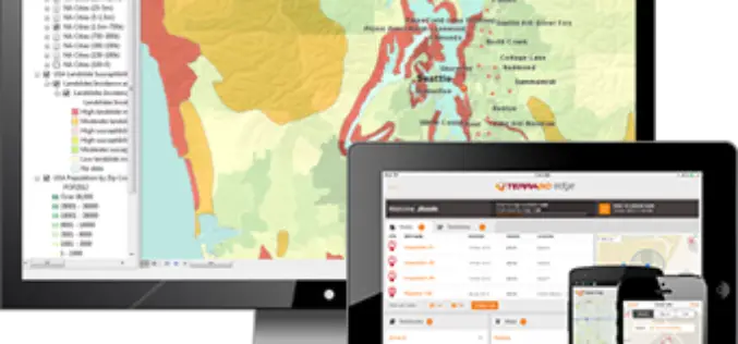
TerraGo Edge Version 3.9.8 Enhances Seamless Integration with Esri ArcGIS
New ArcGIS® Direct Connect feature added to ever-expanding ArcGIS integration options to easily exchange data between ArcGIS and TerraGo mobile data collection solutions Available today, TerraGo Edge version 3.9.8 now
TerraGo Webinar: Connect your ArcGIS with the Edge of the Enterprise
Webinar: Connect your ArcGIS with the Edge of the Enterprise November 15, 2016 | 12:00 PM (ET) Maximize your ArcGIS investment and reach a wider mobile audience, while improving field data

New Esri Workbook Teaches Web GIS App-Building Skills
Redlands, California—The demand for geographic information system (GIS) apps designed for use on the web and mobile devices is skyrocketing, fueling the need for people trained to build and deploy

See Where Imagery and GIS Go Next in The ArcGIS Imagery Book: New View. New Vision.
Learn to Work with Imagery in Esri ArcGIS Using the Book and Companion Website Redlands, California—Getting a more intelligent picture of our planet just got easier thanks to an explosion

Los Angeles Department of Transportation Empowers Smart Communities with Esri Web Map
Spatial View of Los Angeles Mobility Network Shows Street Projects, Paving the Way for a People-Friendly Future Redlands, California—A new public web map, built on the Esri ArcGIS platform, shows
Esri and Safe Software Release Common Framework for Data Exchange among Electrical Power Utilities
Common Information Model Translation Template Enables Data Exchange from GIS to Internal and External Enterprise Systems Redlands, California—Esri and Safe Software have paired to develop and openly share a Common
