
Tag "Bangladesh"
Bangladesh Telecommunication Regulatory Commission Unveils GIS Map of Nationwide Optical Fiber
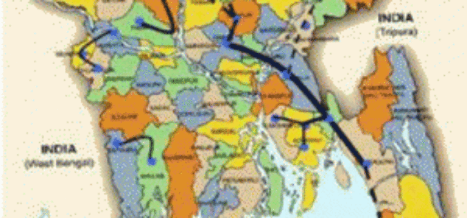
According to recent news by the Prothom Alo, the Bangladesh Telecommunication Regulatory Commission (BTRC) has unveiled a web-based interactive GIS map of optical fiber laid across the country, which shows

Geospatial Tools to Tackle Public Health in Bangladesh
According to recent news published by the University of Texas at Dallas, Geospatial information sciences (GIS) can help determine where diseases are spreading and where to target the resources needed to

Bangladesh Govt to Form National Spatial Data Infrastructure (NSDI)
According to recent news, Prime Minister Sheikh Hasina has said her government would soon form ‘National Spatial Data Infrastructure’ (NSDI) to generate geo-data and digital mapping aimed at country’s planned development.
Esri Joins International Partnership to Enhance Climate Resilience in Developing Countries
Colombia, Ethiopia, and Bangladesh to Harness ArcGIS Platform to Achieve Long-Term Sustainability Redlands, California—In a next phase of support of The White House Climate Action Plan, Esri will donate its best-of-breed
