
Tag "Aerial Imagery"
How AI and Aerial Imagery Can Improve Crop Damage Assessments in Agricultural Insurance
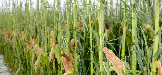
About Author Corey Feduck Director of Business Development at Ceres Imaging As extreme weather events continue to increase in frequency, insurance firms are partnering with agricultural technology companies to gain
Eagleview® Sets New Standard for Aerial Image Capture With Acquisition of Spookfish
Leading provider of aerial imagery and data analytics commits to next-generation aerial image capture technology, advancing industry standards for both image resolution and capture efficiency. Bothell, WA (July 25, 2018) – Eagle

Col-East Inventories Salt Piles from the Air Each Winter in Preparation for Snowy Weather
NORTH ADAMS, Massachusetts, 20 March 2018 – Surveying and Mapping Consultants Inc. (SMC) of Braintree, Mass., has teamed with Col-East International Ltd. for the past 12 years to monitor inventories
Geomni Begins Aerial Imagery Capture of California Wildfires
Flyovers began on Friday, December 8th to authorized areas, complying with FAA regulations that ensure emergency response teams can effectively combat the fires. LEHI ,UT — December 8, 2017 —

DigitalGlobe Completes Testing and Calibration of WorldView-4 and Begins Serving the Satellite’s First Direct Access Customer
WorldView-4 completed its testing and calibration phase and began serving its first direct access customer on February 1st 2017. WESTMINSTER, Colo.–(BUSINESS WIRE)–Feb. 3, 2017– DigitalGlobe, Inc. (NYSE: DGI), the global

New 3D Mapping Technology for Smart City Development
The two most commonly used 3D mapping techniques are photogrammetry using satellite or aerial imagery, and laser scanning. The former offers greater accuracy in the horizontal direction and the latter

Geomatica 2016 Release Highlights
Geomatica 2016 Release Highlights March 15, 2016 | 4:00 AM EST – 9:00 AM (GMT) | 2:00 PM EST – 7:00 PM (GMT) PCI Geomatics is the developer of Geomatica- a complete
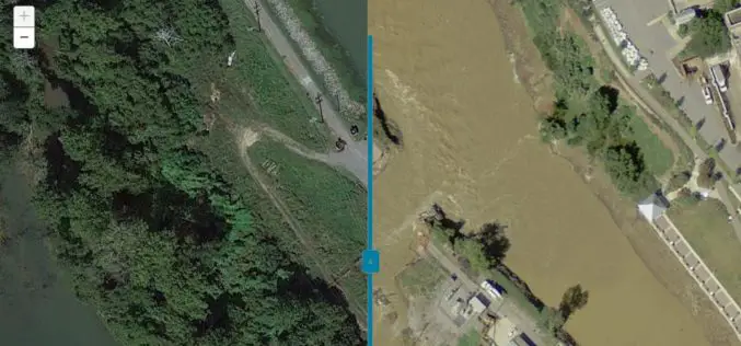
Imagery Assists Disaster Response in South Carolina
COLUMBIA, S.C. (Nov. 4, 2015) — One month ago today, a “thousand-year” rain event hit South Carolina, spurring widespread flooding throughout much of the state. In an effort to address the

81 Villages in Noida To Be Mapped Using Drone
In recent news by ToI, Noida Authority is going to map individual houses of 81 villages in its administrative boundary. Bishanpura village is the first of 81 villages to be

PPT-Aerial Imagery By David Davis, USDA Farm Service Agency, Aerial Photography Field Office
This PPt gives an historical and present overview of how Aerial Photogrammery has changed. Written by: David Davis, USDA Farm Service Agency, Aerial Photography Field Office Download PPT-Aerial Imagery By David Davis
