
Tag "Abu Dhabi"

Abu Dhabi Municipality Launches GIS Platform for Submittal of Road Layout Data
In a major boost and expansion to the e-services, The Abu Dhabi City Municipality (ADM) has launched a platform that allows submittal of roads layout data standards using Geographic Information
Mobile App to Provide Real-time Information of Traffic in Abu Dhabi
According to the Gulf News, Darb mobile app launched by the Department of Transport (DoT), will make smartphones even smarter by helping motorists avoid congested roads and traffic delays through
Abu Dhabi to Host Esri Middle East and North Africa User Conference
Emirate Serves as the Smart Government Role Model for All Nations in the Region to Replicate Redlands, California—For almost a decade, Abu Dhabi, United Arab Emirates, has typified smart government—primarily
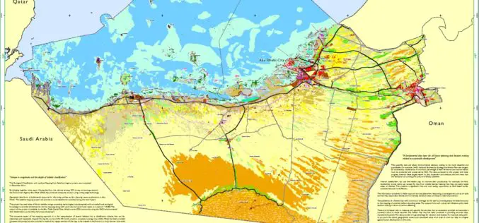
Habitat Mapping to improve Biodiversity and Crisis Management
The Environment Agency-Abu Dhabi (EAD) has completed an ambitious project of habitat mapping (terrestrial and marine), landuse and landcover for the Emirate of Abu Dhabi. The mapping of habitats will help

GIS to Add Traffic Intelligence in Abu Dhabi
In recent news, Abu Dhabi is using a unique intelligence system “Intelligent Safety Management System” which uses Geographical Information System to create solutions for certain problems such as speeding and
