
Tag "3D models"
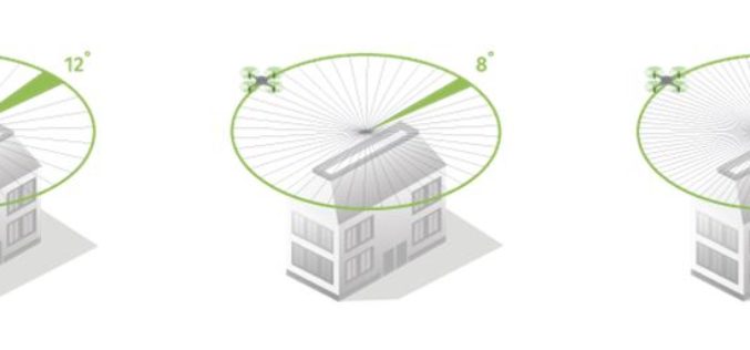
How Do I Choose the Right Image-capture Settings for 3D Models?
How do I choose the right image-capture settings for 3D models? What are the effects of the “angle between images” setting in circular missions when it comes to 3D reconstruction?

DigitalGlobe Completes Testing and Calibration of WorldView-4 and Begins Serving the Satellite’s First Direct Access Customer
WorldView-4 completed its testing and calibration phase and began serving its first direct access customer on February 1st 2017. WESTMINSTER, Colo.–(BUSINESS WIRE)–Feb. 3, 2017– DigitalGlobe, Inc. (NYSE: DGI), the global

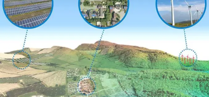
Introducing TerraSmart’s New Fleet of High Precision Aerial Site Mapping Drones
High-Precision Aerial Site Mapping Drones Streamlines Site Topography for Faster and More Profitable Solar TerraSmart proves once more that autonomous technology brings increased precision, speed and cost-savings to the

PDF3D Announces Support for macOS Sierra
Advanced 3D PDF authoring software suite supports the latest Macintosh® OS release. London, UK, October 27th, 2016 – PDF3D, from Visual Technology Services, today reaffirmed its commitment to Apple technology

Icaros Releases 4.2.2 of OneButton UAS Image Processing Software
FAIRFAX, Virginia, USA – Icaros Inc., a leading provider of aerial imaging software, is pleased to announce Release 4.2.2 of OneButton. The release contains new features and improvements as well as

AECOM and Trimble Pioneering Use of Mixed-Reality Technology for Engineering and Construction
Bridging the Digital and Real Worlds to Enable Improved Communication and Collaboration on Projects Spanning Three Continents LOS ANGELES and SUNNYVALE, Calif., June 13, 2016—AECOM (NYSE: ACM) and Trimble (NASDAQ:
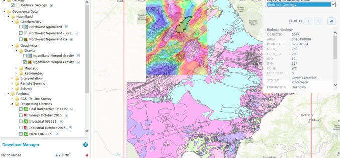
Botswana Geoscience Portal Goes Live
Online portal improves access to geoscience data from Africa Geosoft recently announced the launch of the Botswana Geoscience Portal, a partnership initiative with the Botswana Geoscience Institute and industry sponsors. Developed
Aerial Mapping Pioneer Bluesky Supports Clean Energy Campaign
Aerial mapping company Bluesky is backing a charity’s campaign to protect the subsidies for clean energy projects. Under recent Government proposals, changes to the Feed-in-Tariffs (FiTs) for wind, solar and
Esri CityEngine 2015 Provides Advanced 3D City Design
New Features Provide a Faster, More Intuitive Experience for Modeling Virtual 3D Urban Environments Redlands, California—The release of Esri CityEngine 2015 allows GIS professionals, architects, planners, and urban designers to

New 3D imagery for Google Earth
Since 2006, we’ve had textured 3D buildings in Google Earth, and we’re excited to announce that we’ll begin adding 3D models to entire metropolitan areas to Google Earth in the
