Supergeo Technologies, the global leading GIS software and solution provider, announces that Star Vision Ltd., Supergeo Certified Reseller in Hong Kong, Macau and Guangdong, utilizes SuperGIS in a charity map project for Hong Kong Orienteering Club (HKOC).
Founded in 1979, HKOC is the first organization which promotes orienteering in Hong Kong. As a member of IOF (International Orienteering Federation), HKOC holds numerous events to train the public with the nature and advantages of orienteering. The activity greatly combines map reading, physical ability and adaptability in strange wild environment for the public.

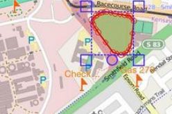
Utilizing GIS, the map project integrates diverse geospatial resources and platforms, for promoting e-map in orienteering sport. Star Vision, the official map promoter of Lands Department, Hong Kong Government, helps HKOC produce detailed basemap for orienteering competition, as well as assists HKOC volunteers in using GIS in the field.
The staff produces 1:1,000 digital basemap with orthorectified aerial photographs through SuperGIS Desktop, the powerful desktop GIS software to process geospatial data, and then creates digital elevation model with SuperGIS 3D Analyst, so that slope, aspect, elevation and other information can be well visualized on the map, and the field workers can control and update data easily.
Furthermore, Star Vision trains HKOC field checkers with SuperSurv, a GIS data collection app for Android and iOS, so that they can check, record and edit boulder, footpath, and vegetation boundaries data with their mobile devices freely. As for efficiency, SuperSurv can receive high accuracy GNSS signals and create point, line, and polygon data on site. IOF standard in 1:10,000 mapping is usually 5m, but SuperSurv provides much better accuracy to enhance the field productivity.
SuperGIS Desktop free trial: http://www.supergeotek.com/download_6_desktop.aspx
SuperSurv free trial Android: https://play.google.com/store/apps/details?id=com.supergeo.asd.supersurvlite.SuperSurv
iOS: https://itunes.apple.com/us/app/supersurv/id734191604?ls=1&mt=8
# # #
About Supergeo
Supergeo Technologies Inc. is a leading global provider of GIS software and solutions. Since the establishment, Supergeo has been dedicated to providing state-of-the-art geospatial technologies and comprehensive services for customers around the world. It is our vision to help users utilize geospatial technologies to create a better world.
Supergeo software and applications have been spread over the world to be the backbone of the world’s mapping and spatial analysis. Supergeo is the professional GIS vendor, providing GIS-related users with complete GIS solutions for desktop, mobile, server, and Internet platforms.
Marketing Contact:
Patty Chen
Supergeo Technologies Inc.
5F, No. 71, Sec. 1, Zhouzi St., Taipei, 114, TAIWAN
TEL:+886-2-2659 1899
Website: http://www.supergeotek.com
Email: patty@supergeotek.com