SoilGrids1km — Global Soil Information Based on Automated Mapping
By- Tomislav Hengl, Jorge Mendes de Jesus, Robert A. MacMillan, Niels H. Batjes, Gerard B. M. Heuvelink, Eloi Ribeiro, Alessandro Samuel-Rosa, Bas Kempen,Johan G. B. Leenaars, Markus G. Walsh, Maria Ruiperez Gonzalez
This paper, present and describe SoilGrids1km — a global 3D soil information system at 1 resolution — as a first response to the need for a new, consistent and coherent, global soil information. SoilGrids1km was produced using the Global Soil Information Facilities (GSIF), which was recently developed at ISRIC as a framework and platform to support widespread, open collaboration in the assembly, collation and production of global soil information.
Abstract
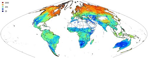
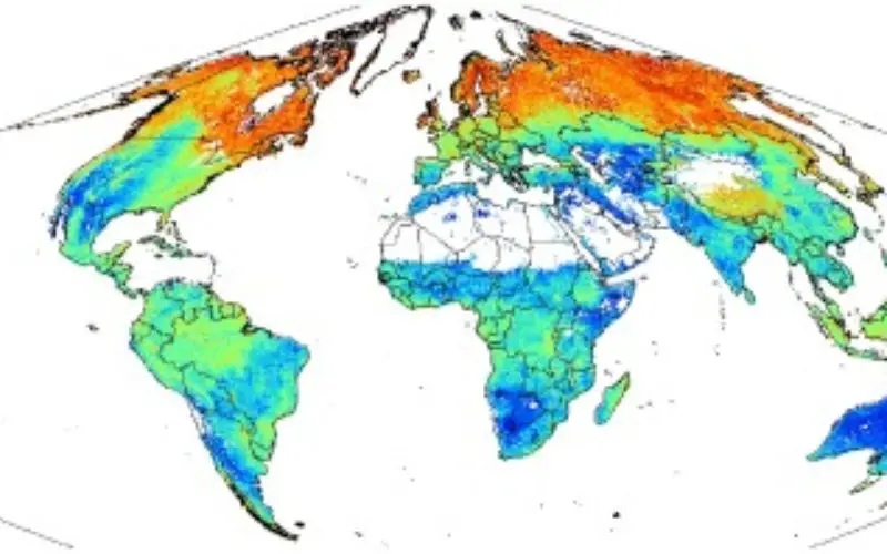
Predicted global distribution of the soil organic carbon stock in tonnes per ha for 0–200 centimetres.
Background: Soils are widely recognized as a non-renewable natural resource and as biophysical carbon sinks. As such, there is a growing requirement for global soil information. Although several global soil information systems already exist, these tend to suffer from inconsistencies and limited spatial detail.
Methodology/Principal Findings: The paper present SoilGrids1km — a global 3D soil information system at 1 km resolution — containing spatial predictions for a selection of soil properties (at six standard depths): soil organic carbon (g kg−1), soil pH, sand, silt and clay fractions (%), bulk density (kg m−3), cation-exchange capacity (cmol+/kg), coarse fragments (%), soil organic carbon stock (t ha−1), depth to bedrock (cm), World Reference Base soil groups, and USDA Soil Taxonomy suborders. Our predictions are based on global spatial prediction models which we fitted, per soil variable, using a compilation of major international soil profile databases (ca. 110,000 soil profiles), and a selection of ca. 75 global environmental covariates representing soil forming factors. Results of regression modeling indicate that the most useful covariates for modeling soils at the global scale are climatic and biomass indices (based on MODIS images), lithology, and taxonomic mapping units derived from conventional soil survey (Harmonized World Soil Database). Prediction accuracies assessed using 5–fold cross-validation were between 23–51%.
Conclusions/Significance: SoilGrids1km provide an initial set of examples of soil spatial data for input into global models at a resolution and consistency not previously available. Some of the main limitations of the current version of SoilGrids1km are: (1) weak relationships between soil properties/classes and explanatory variables due to scale mismatches, (2) difficulty to obtain covariates that capture soil forming factors, (3) low sampling density and spatial clustering of soil profile locations. However, as the SoilGrids system is highly automated and flexible, increasingly accurate predictions can be generated as new input data become available. SoilGrids1km are available for download via http://soilgrids.org under a Creative Commons Non Commercial license.
Click to Read full Paper – SoilGrids1km — Global Soil Information Based on Automated Mapping