 The Institute for Spatial and Landscape Development, ETH Zurich is looking for a PhD student in ecosystem service mapping.
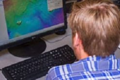
The PhD student will be part of the EU Horizon2020 ECOPOTENTIAL project, which aims to make earth observation and monitoring data usable for ecosystem modelling and services. The PhD student will create a generic toolbox to map ecosystem services in and around protected areas in Europe. Bayesian Networks will be used to link remote sensing data to a range of ecosystem services. The toolbox will be tested in the mountainous region surrounding Davos (Switzerland) and applied to other protected areas in the ECOPOTENTIAL project. Results will be published in peer-reviewed journals and presented at international conferences. The PhD student will be mostly based at the Planning of Landscape and Urban Systems Group (Adrienne Grêt-Regamey) of ETH Zurich, but also with the Mountain Ecosystems Group at the WSL Institute for Snow and Avalanche Research SLF in Davos (Peter Bebi).
Candidate Profile:
A highly motivated applicant with a Master in Landscape Planning, Environmental Sciences, Geography or related discipline, who has experience with remote sensing image interpretation and/or computer programming (e.g. R, python, Matlab). The applicant should also be skilled in GIS (e.g. ArcGIS, QGIS). Ideal candidates have experience with ecosystem service mapping and/or Bayesian Networks. Furthermore, the applicant should have a good command of English (both written and spoken) and should be willing to communicate with and work in a large interdisciplinary Project.
How to Apply
Applications with cover letter, CV, testimonials and names and contacts of two referees should be sent online via the blue “apply now” button below with attention to:
ETH Zurich,
Mrs. Corina Niescher,
Human Resources, CH-8093 Zürich.
Apply Now
For further information please contact Prof. Dr. Adrienne Grêt-Regemy by e-mail gret@ethz.ch (no applications) and visit our website www.irl.ethz.ch.
Read more at https://goo.gl/2aT3qN