 Orbit GeoSpatial Technologies has released Orbit Softcopy version 11, the photogrammetric mapping solution from the Orbit GT portfolio.
“Orbit Softcopy is the first version 11 upgrade within our Photogrammetry portfolio.“, says Peter Bonne, CEO at Orbit GT. “We’re very pleased to present this major upgrade and provide powerful new tools to our customers worldwide.”
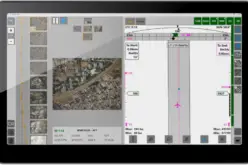
Orbit Softcopy brings the complex techniques of stereo mapping down to common use, on every desktop. It enables the user to perform any stereo mapping operation, while having access to all GIS functionalities such as object editing, object inspection, symbolics, and access to corporate resources on a central server. This release puts stereo imagery as a standard and easiy available source of mapping data within your organization.
Version 11 delivers an extremely smooth import workflow for all stereo projects: just complete the required steps based on EO file, Calibration Report, and Imagery and your mapping job can be started. Navigate seamlessly in stereo, without the need to select a single stereo couple, but use the Orbit standard all-in-one mapping environment. Version 11 includes a complete cover of GIS integrated mapping tools (e.g. rotation, editing, selection, construction lines, etc.). With the seamless connectivity between 2D view and stereo view, it redefines the standard way of vectorization, syncing 2D and stereo instantly and providing access to the 2D and stereo interactive tools simultaneously. This provides an extremely fast production workflow : Map in stereo, edit in 2D, attribute as in GIS.
About Orbit GeoSpatial Technologies:
Orbit Geospatial Technologies is world leader in solutions for exploiting Mobile Mapping, UAS and Aerial Mapping data in managing, viewing, extracting, publishing, sharing and embedding in workflows. Orbit GT is headquartered in Lokeren, Belgium.