OGC Announces New Discrete Global Grid Systems Standards Working Group
 The Open Geospatial Consortium (OGC®) announces the formation of a new OGC Technical Committee Standards Working Group (SWG). The purpose of this SWG will be to explore and propose terms for a standard to enable interoperability through the use of Discrete Global Grid Systems (DGGS). The OGC members convening this group invite the public to comment on the DGGS SWG charter ( https://portal.opengeospatial.org/files/57326 ) and will consider comments received via email to charter-requests AT opengeospatial.org before 11 April 2014.
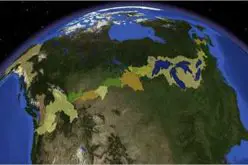
Unlike the widely used coordinate reference systems that represent the Earth as a continual lattice of points, a DGGS represents the Earth with a tessellation of nested cells. A DGGS is designed to ensure a repeatable representation of measurements that is better suited to today’s requirements and technologies than our legacy coordinate systems that were designed for repeatable navigation and manual charting.
There is explosive growth of both the variety and the volume of interesting spatial data and processing resources, along with a growing understanding of the tremendous societal benefit that can be derived from enabling interoperability between them. On the other side of this deluge of spatial content is a growing demand by end-use decision-makers for a participatory environment where content can be accessed directly from diverse contributors and used with other content without reliance on time-consuming and costly pre-integration processes.
One of the core contributions of a DGGS is geospatial fusion on demand. In a multiple provider environment, fusion is only possible with an information system architecture based upon open standards. There is a need for the development of a standard to enable interoperability within and between Discrete Global Grid Systems and to promote reusability, knowledge exchange, and choices between different data sources and architectures.
The DGGS SWG will consist of interested parties from across a broad range of the geosciences, academic institutions, and commercial and government organizations that are involved with or interested in the design, development, implementation or use of Discrete Global Grid Systems.
The conveners of the DGGS SWG are Matthew Purss of Geoscience Australia, Perry Peterson of PYXIS Innovations Inc. and Robert Gibb of Landcare Research New Zealand.
The following Charter Members support this proposal and are committed to the Charter and projected meeting schedule. Others may join this list before the SWG is officially chartered.
Name Organization
Clinton Foster Geoscience Australia (Chief Scientist)
Matthew Purss Geoscience Australia
Perry Peterson PYXIS Innovations
Robert Gibb Landcare Research NZ
Simon Oliver Geoscience Australia
Faramarz Samavati University of Calgary
Robert Woodcock CSIRO
Ben Evans National Computational Infrastructure, Australian National University
The OGC is an international consortium of more than 470 companies, government agencies, research organizations, and universities participating in a consensus process to develop publicly available geospatial standards. OGC standards support interoperable solutions that “geo-enable” the Web, wireless and location-based services, and mainstream IT. OGC standards empower technology developers to make geospatial information and services useful with any application that needs to be geospatially enabled. Visit the OGC website at http://www.opengeospatial.org/contact.