NCTech Set To Transform Laser Scanning Market with HDR Point Cloud Colourisation Software

Scottish company launches world’s fastest automatic high resolution HDR point cloud colourisation
Breakthrough technology will mean end for stitching, processing images and manually clicking placement points
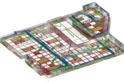
 NCTech has launched ColourCloudTM, the world’s fastest automatic HDR point cloud colourisation technique, which offers pixel-perfect overlay for any scanner supporting e57 and LAS industry standards.
The company is already globally renowned for its ground-breaking iSTAR® digital imaging device, recognised as the most accurately calibrated 360 degree camera in the world. Itnow heralds in its new ColourCloud process as a significant breakthrough to provide a fully automatic colour overlay solution that speeds up workflow, requires no stitching, resolves parallax and is precision calibrated to sub pixel accuracy producing overlay results within only +/-2 pixelsproviding full HDR rich colour overlay for any laser scan.
Moreover, since ColourCloud and the iSTAR® camera are both fully automated, there is no specialist knowledge required to capture images or use the ColourCloud software. ColourCloud is used on a ‘drag and drop’ basis, so by dropping the laser scan andiSTAR® images onto it, hundreds of millions of measurements will be colourised in seconds. This ease of use and speed has the potential to colour hundreds of every day.
Extremes of light don’t inhibit performance either. The iSTAR® 360 camera is capable of capturing any scene in full colour regardless of contrasting light conditions. iSTAR capturesan impressive 27ev range of light, where internal cameras on most scanners are unable to cope with low light conditions making this robust combination perfect for night scene capture.
NCTech founders Neil Tocher and Cameron Ure are excited by this significant milestone in offering the laser scanning market an innovative step-change solution.
Neil Tocher comments;
“ColourCloud is a breakthrough in automatic point cloud colourisation.Traditional methods employ the user to undergoing many steps to capture, stitch, and overlay the data with varying degrees of success.ColourCloud is an entirely new approach and redefines the process with total automation.
Designed to build on iSTARs automation, speed and hi resolution. ColourCloud will streamline the workflow of the entire industry whilst delivering a leap in visual quality and detail.”
The next step for NCTech is to develop ColourCloud into a mobile product, as Cameron Ureexplains;
“Our R&D team is working to bring ColourCloud onto a mobile platform. iSTAR® is already a great mobile mapping tool, so combined with ColourCloud ‘Mobile’, users will be able to automatically colourise an entire point cloud instead of only having colour spheres placed onto the scan at intervals.
ColourCloudMobile will take thousands of iSTAR®images and automatically colourise them throughout each step of the journey, providing a vivid, fully coloured point cloud which could be several kilometres in size.”
The concept for iSTAR®was to create the world’s fastest 360 degree camera capable of measurements directly from its own images, without any other hardware. This is possible due to the unique calibration process and precision engineering of iSTAR®. Its measurement capability produces an accuracy of +/- 10mm within a 10 meter radius. This enables in-field users to produce reports with images, measurements and descriptions at the touch of a button.
Contacts
Neil Tocher, Co-Founder and CTO NCTech: t: 0131 202 6258
Cameron Ure, Co-Founder and CEO NCTech: t: 0131 202 6258
Kevin Dorrian, Acumen PR: t: 0131 661 7027 m: 07786 386300