NavVis Introduces Cloud Processing for Even Faster Laser Scanning Workflows
From processing to viewing, with NavVis it can now be done entirely in the cloud.
NavVis, an innovator in indoor mobile mapping, today introduced the Cloud Processing Add-on for NavVis IndoorViewer, a cloud-based tool that enables users to quickly and easily convert laser scans into survey-grade, photo-realistic point clouds from data captured by NavVis M6 and the new wearable device, NavVis VLX.
The fully integrated NavVis indoor mapping solution is relied upon by laser scanning service providers, professional surveying firms, and Architecture/Engineering/Construction (AEC) companies.
“We wanted to offer our users a processing tool that significantly speeds up and simplifies their workflows, so they can benefit both in the short and long term,” said Lisa Cali, NavVis Product Head for Web & Cloud. “The Cloud Processing Add-on for NavVis IndoorViewer makes this possible.”
NavVis revolutionized indoor mobile mapping with the introduction of trolly and wearable mobile data collection systems that rapidly capture survey-grade point clouds and 360° HD imagery in spaces such as manufacturing facilities, office buildings, and construction sites. Once the data is captured, the entire NavVis post-processing and visualization workflow can now be conducted in the cloud.
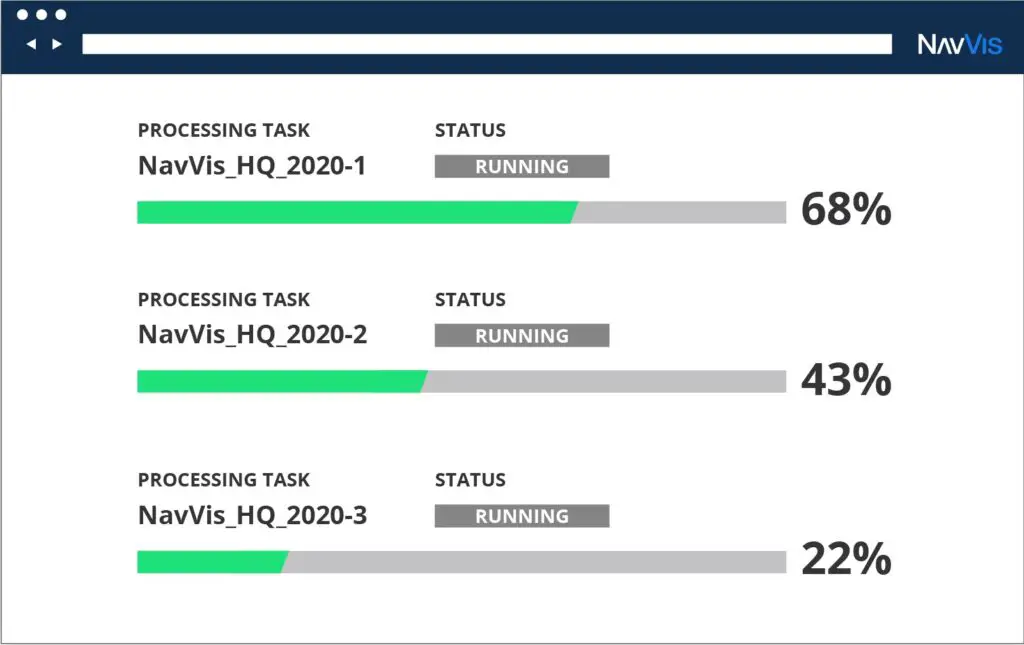
NavVis users traditionally invest in their own computing infrastructure to convert the scan data into photorealistic point clouds, a timely process even with a powerful desktop computer. Now with the Cloud Processing Add-on for NavVis IndoorViewer, users have the option to upload multiple datasets from anywhere with an internet connection and quickly process enormous data volumes by maximizing the power of cloud computing.
“Powerful cloud computing makes the NavVis processing workflow faster and more efficient, allowing multiple data sets to be processed in parallel while, at the same time, ensuring advanced data security,” said Cali
In addition, NavVis has streamlined the new processing software for easier uploads and set up. The intuitive interface enables the user to choose point cloud settings in advance and flags potential errors that could interrupt the run. Processing begins automatically and throughout the task, the user can view a live progress bar and even request to receive an email notification when the job is complete.
“Incredibly straightforward and a true time saver. The convenience of the cloud allows us to process multiple datasets from any location,” said beta program participant Neil Wakeman, BIM Technology Lead, Wade Trim Group.
Conveniently, this new tool is featured within NavVis Cloud, the cloud-based, on-demand version of NavVis IndoorViewer. This means that once data has been processed, users can instantly view and intuitively interact with their processed data in the form of 360° immersive imagery, survey-grade point clouds and customizable floorplans. Any user with a web browser can ‘walk through’ the virtual scene, even annotating and measuring their space, as if they were on site.
The Cloud Processing Add-on for NavVis IndoorViewer is now available. Get more information at www.navvis.com/indoorviewer/cloud-processing-add-on.
About NavVis:
Bridging the gap between the physical and digital world, NavVis enables service providers and enterprises to capture and share the built environment as photorealistic digital twins. Our SLAM-based mobile mapping systems generate high-quality data with survey-grade accuracy at speed and scale. And with our digital factory solutions, users are equipped to make better operational decisions, boost productivity, streamline business processes, and improve profitability. Based in Munich, Germany, with offices in New York and Shanghai, NavVis has customers worldwide in the surveying, AEC, and manufacturing industries. For more information, visit www.navvis.com.
Also Read –
NavVis IndoorViewer Now Converts Static Scans Into Immersive 360° Imagery