 LizardTech, a provider of software solutions for managing and distributing geospatial content, announced the launch of GeoExpress 9.5 at this week’s Esri International User Conference, California.
GeoExpress enables geospatial professionals to compress and manipulate satellite and aerial imagery. In addition to compressing raster data, GeoExpress 9.5 now supports compressing LiDAR point clouds stored in plain-text format (ASCII files) or in the LAS and LAZ formats. The output image is stored in the MrSID Generation 4 format or the LAZ format (saving up to 75% on storage space without compromising on speed or visual quality).
GeoExpress 9.5 supports batch color balancing operations on multiple images. Previously, you could only color balance single images and mosaics.
The new version you can crop images, you can define the area that you want to crop with a shapefile. The shapefile that you select can contain multiple polygons (batch processing). You can then create a single image that contains the area of all the polygons, or you can create separate images for each polygon. Previously, shapefiles needed to contain exactly one polygon.
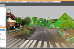
GeoExpress 9.5 also features to explore point clouds data in 3-D mode directly from GeoExpress.
Download Trail of GeoExpress 9.5
About LizardTech
Since 1992, LizardTech has delivered state-of-the-art software products for managing and distributing massive, high-resolution geospatial data such as aerial and satellite imagery and LiDAR data. LizardTech pioneered the MrSID technology, a powerful wavelet-based image encoder, viewer, and file format. LizardTech has offices in Seattle, Denver, London and Tokyo. For more information about LizardTech, visit www.lizardtech.com.