Leica Introduce Leica Pegasus: Backpack Industry First Wearable Reality Capture

Leica Geosystems announced the commercial availability of Leica Pegasus: Backpack this week at HxGN LIVE.
Leica Pegasus: Backpack is first of its kind in geospatial industry. It comes with a combination of five high-dynamic cameras, which work in a variety of light conditions, and a LiDAR profiler with an ultra-light and ergonomic carbon fibre chassis.
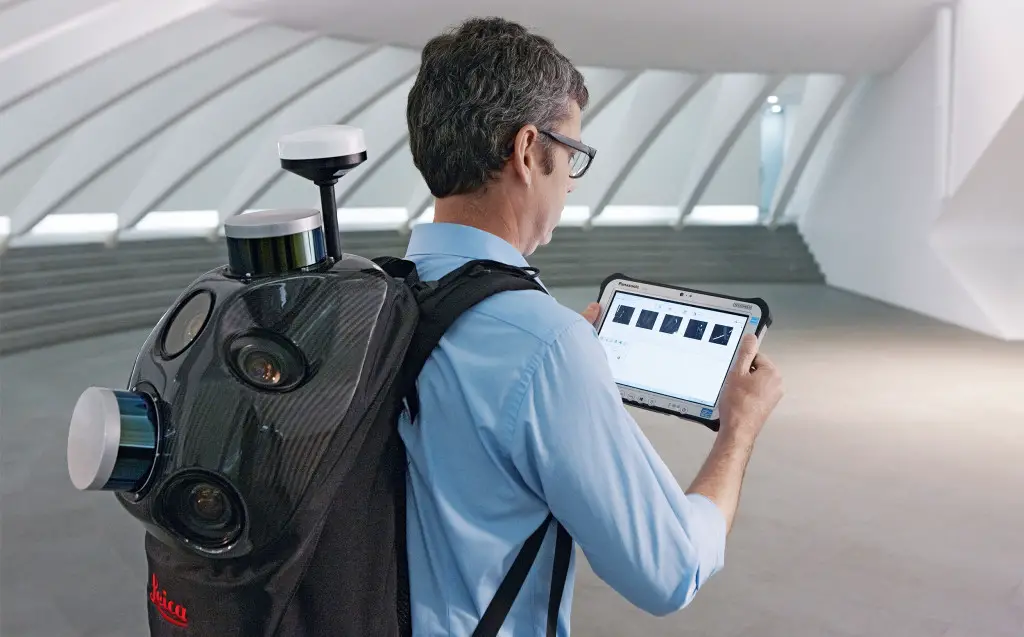
The Leica Pegasus:Backpack creates a 3D view indoors or outdoors for engineering or professional documentation creation at the highest level of authority yet.
This backpack mobile mapping solution is a great option for reality capturing and to create a 3D view indoors or outdoors for engineering or professional documentation creation at the highest level of authority yet. Leica Pegasus: Backpack creates the most realistic view by capturing synchronized imagery and point cloud data. It uses Simultaneous Localization and Mapping, or SLAM, technology for accurate positioning in GNSS restricted areas. The Leica Pegasus: Backup also comes with a high precision inertial measurement unit (IMU) for position – agnostic solution.
For Building Information Modeling, or BIM, or simply for capturing 2D square foot updates to a large building, the Leica Pegasus: Backpack creates the most realistic view by capturing synchronized imagery and point cloud data.
With full 360-spherical views and LiDAR together plus a hardware light sensor, all images are usable while other functions are verifiable and adjustable over the operator’s tablet device. The system uses multiple hot-swappable batteries, making even long captures possible.
This new technology is designed to enable weekly data capture efficiently and cost effectively for changing building construction sites. For the first time, this enables the creation of a full starting document for authoritative 6D management of a building or simply to provide an authoritative hand-off dataset to a new building owner. By capturing weekly during a building’s construction, an “x-ray” view of the building is created. As the Backpack clearly logs position and time with the advanced measurement of LiDAR, change orders in the construction process can now offer a complete new level of authority for quality construction while scheduled milestones are achieved.
“With the Leica Pegasus:Backpack, limited-access outdoor areas or underground infrastructures are no longer limited in professional data collection,” said Stuart Woods, Geospatial Solutions Division vice-president. “Users will never again forget any aspect of any job nor need to return to a project site. They can capture everything by simply arriving on site wearing the technology, capture and leave, rest assured they have everything they need to complete the job on time and on budget.”