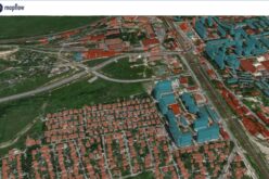
 KOLHAPUR, Maharashtra: According to recent news by ToI, the Kolhapur Municipal Corporation (KMC) is planning to harness the power of Geographic Information System (GIS) technology for planning and determining land use patterns required for drafting city’s development plan.
The current development plan which is being used by Kolhapur Municipal Corporation was drafted in 2000 and the implementation period of the plan ends in 2020. The KMC has set a deadline of 2019 to complete the processes required to draft the new DP and then it will be sent to the state government for sanctioning.
The GIS technology will be used for the first time for drafting the development plan by the KMC. The civic body will send a team of town planning officials to meet their counterparts from Pune Municipal Corporation (PMC) to study various steps involved in drafting the DP.
P Siva Sankar, KMC municipal commissioner, said,
“We are going to begin the work of drafting the DP soon. We have decided to use GIS method to determine land use patterns. A team of officials will study the development plan of Pune. Earlier, the DPs were manually drafted and posed challenges in case circumstantial changes were required. The proposed land use will be sent to the state government for final approval.”