 The European Space Agency (ESA) has launched a new project – GlobTemperature to capture earth land surface temperature (LST) at global scale. Instruments like thermometer there are several satellite sensor are in the sky to measure the temperatures of Earth’s surface.
ESA’s GlobTemperature project is merging these data from a variety of spaceborne sensors to provide scientists with a one-stop shop for land, lake and ice temperature data.
The GlobTemperature project was launched under the Data User Element Programme and will merge surface temperature data from a variety of satellites into a common format which will be made available in a single online archive.
Land surface temperature data plays an important role in studying the Earth system. And it also plays as important component in physical process such as atmospheric convection and surface evaporation, biological processes like vegetation sensitivity to stress and to fire, and chemical processes such as emissions of gases from the surface to the atmosphere.
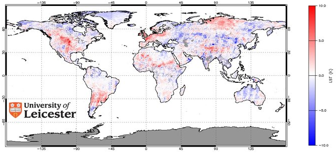
Spatio-temporal data for land surface temperature can also be an indicator of climate change. Land surface temperature data in combination with other metrological data is very useful in studying drought monitoring and modeling.
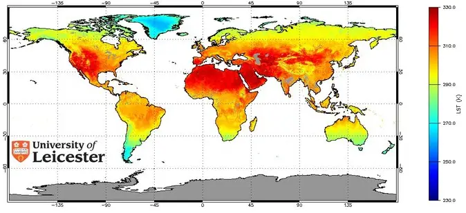
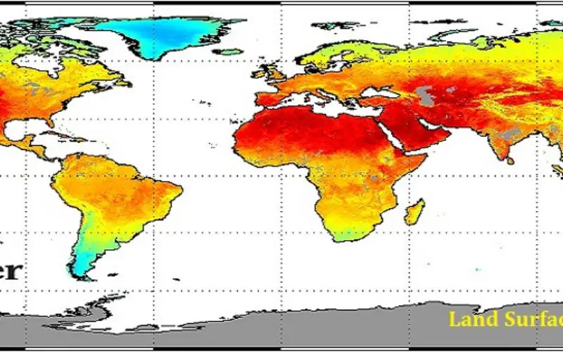
Land Surface Temperature
Researchers rely heavily on air temperature measurement made using ground based weather stations despite the availability of satellite-derived measurements. This is mainly due to the complexity of the data from different satellite instruments, utilizing both infrared and microwave data, and the variety of formats in which the data are made available. More over it is also difficult to convert the satellite measurements of the temperature of the solid land surface to the commonly used air temperature. In addition, satellite data suffer from gaps due to cloud cover or provide limited sampling of the day/night temperature cycle.
To fill these gaps and better meet users’ needs for land surface temperature data, ESA recently initiated the GlobTemperature project under the Data User Element Programme.
GlobTemperature will merge surface temperature data from a variety of satellites into a common format which will be made available in a single online archive.
“One-stop shop for land, lake and ice temperature data – measured by satellites.”
GlobTemperature project will use data from instruments including SEVIRI on Europe’s MSG mission, AVHRR and IASI on MetOp, as well as American and Japanese instruments and from the upcoming Sentinel-3 mission. Archived data from the (A)ATSR instruments flown on the ERS and Envisat missions will also be included.
The new, global datasets developed under GlobTemperature will provide a more complete representation of day and night temperatures, including estimates of clear-sky versus cloudy sky biases.
Professor John Remedios from the Department of Physics and Astronomy at the University of Leicester, who leads the project, said:
“Satellite observations of land surface temperatures, and their change, are increasingly important for evaluating models of the Earth system and for observing long-term change. This Leicester-led project will be transformative through the innovative methods and unique data sets that users will be able to use as a result to investigate temperature change.”
The new global datasets to be developed under GlobTemperature will provide a more complete picture of day and night temperatures.
Temperature Changes
The GlobTemperature project will:
- Develop a merged LST data set from thermal infrared (geostationary & polar orbiter) and passive microwave satellite data to provide best possible coverage, including information on the diurnal cycle and clear-sky bias
- Develop a prototype LST climate data record from (A)ATSR
- Perform an open intercomparison of methods to confront the user demand for better cloud clearing over land
- Demonstrate the benefits of satellite LST through user case studies
- Provide users with a single point of access to multi-mission satellite land, lake and ice surface temperature data sets in a harmonised format, including consistently generated uncertainty budgets, documentation, and quality information obtained through intensive intercomparison and validation
- Engage with the user community, respond to feedback, and bring the user and developer communities together
- Challenge the next generation of satellite LST products to better meet the requirements of the users.
For further information, please contact GlobTemperature Project Scientist, Dr Darren Ghent,djg20@le.ac.uk
Source: ESA