Enhanced Elevation Data for North and South America, Pacific Islands, Northern Europe

New Heights of Global Topographic Data Will Aid Climate Change Research
 The U.S. Geological Survey announced today that improved global topographic (elevation) data are now publicly available for North and South America, Pacific Islands, and northern Europe. Similar data for most of Africa were previously released by USGS in September.
The data have been released following the President’s commitment at the United Nations to provide assistance for global efforts to combat climate change. The broad availability of more detailed elevation data across the globe through the Shuttle Radar Topography Mission (SRTM) will improve baseline information that is crucial to investigating the impacts of climate change on specific regions and communities.
“We are pleased to offer improved elevation data to scientists, educators, and students worldwide. It’s free to whomever can use it,” said Suzette Kimball, acting USGS Director, at the initial release of SRTM data for Africa in September. “Elevation, the third dimension of maps, is critical in understanding so many aspects of how nature works. Easy access to reliable data like this advances the mutual understanding of environmental challenges by citizens, researchers, and decision makers around the globe.”
The SRTM30 datasets resolve to 30-meters and can be used worldwide to improve environmental monitoring, advance climate change research, and promote local decision support.
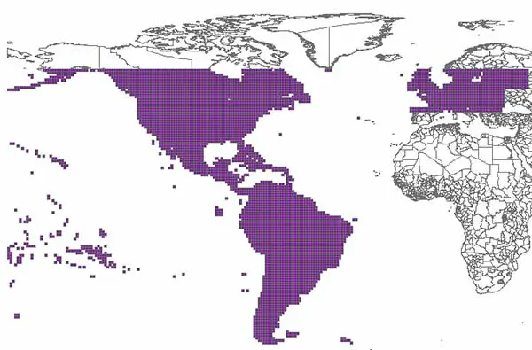
Improved topographic (elevation) data are now publicly available for North and South America, Pacific Islands, and northern Europe as shown in the diagram. Similar data for most of Africa were previously released by USGS in September.
The National Aeronautics and Space Administration (NASA) and the National Geospatial-Intelligence Agency (NGA) worked collaboratively to produce the data, which have been extensively reviewed by relevant government agencies and deemed suitable for public release. The previous global accuracy standard for this data was 90-meters.
The USGS, a bureau of the U.S. Department of the Interior, distributes the data free of charge via its user-friendly Earth Explorer website.
Enhanced 30-meter resolution data for the rest of the world will be released in coming months.
Contact Information:
Jon Campbell ( Phone: 703-648-4180 );