
Software
PR: Esri Announces Climate Resilience App Challenge 2014
Esri, the world leader in mapping technology, unveiled The Esri Climate Resilience App Challenge 2014, calling all developers to create an app using the Esri ArcGIS Platform to help communities, see,

Esri Launches Geotrigger Service for Mobile Developers
Location-Based Messaging Added to iPhone and Android Apps with Minimal Battery Drain February 19, 2014, Redlands, California—Esri announced today that its cloud-based Geotrigger Service is now available, making it easier for developers to
OpenLayers 3 Is Coming
Beta 2 Is Here OpenLayers 3 has been a long time in the making. With the library stabilizing and becoming more feature complete, we’re excited that our efforts are finally coming to

Clark Labs Introduces Land Change Modeler for ArcGIS 10.2!
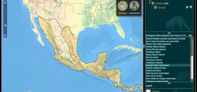
Land Change Modeler for ArcGIS is an innovative land planning and decision support software extension to ArcGIS. Widely used for the prioritization of conservation and planning efforts, Land Change Modeler
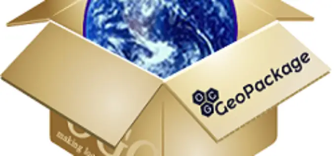
PR: OGC Adopts Important GeoPackage Standard for Mobile
The Open Geospatial Consortium (OGC®) has adopted the OGC GeoPackage 1.0 (GPKG) Encoding Standard. The GeoPackage standard will make it much easier to exchange and share geospatial (or location) information

Bhuvan Updates: Gateway to Indian Earth Observation
On the occasion of NRSC User Interaction Meet – 2014, Bhuvan has been enriched with several features, data products and Services. Bhuvan 2.5D Bhuvan now brings 2.5 D City Models

TatukGIS Releases 64 Bit Version of Free GIS Viewer
TatukGIS announces release of the 64 bit version of its popular free desktop GIS Viewer. Now the free Viewer, like its more powerful sibling the TatukGIS Editor, is available as

AutoTrace Plugin for QGIS
AutoTrace is a plugin for QGIS that allows you to trace existing features. The AutoTrace plugin is based on the traceDigitize plugin by Cédric Möri and others. Installation AutoTrace is available from the

Introducing Geocortex Essentials 4.0
This introduction comes from Geocortex Blog by Latitude Geographics written by Drew Millen on Feb. 05, 2014 … After eighteen months of infrastructure development, we have reached an important milestone in

Navitel Navigator Releases Q1 2014 Update of Maps of Europe, Central Asia, Russia and Turkey
Q1 2014 update of NAVITEL® maps of Europe, Central Asia, Russia and Turkey announced! The users of Navitel Navigator can update maps of Europe, Central Asia, Russia and Turkey up to the Q1 2014 version. The Q1 2014
