
Research Papers
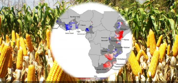
Water, Water — Not Everywhere: Mapping Water Trends for African Maize
Today’s food production relies heavily on irrigation, but across sub-Saharan Africa only 4 percent of cultivated land is irrigated, compared with a global average of 18 percent. Small-scale farming is
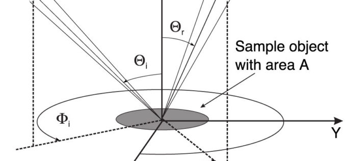
Monostatic Measurement of the Polarized Bidirectional Reflection Distribution Function
Monostatic Measurement of the Polarized Bidirectional Reflection Distribution Function by Oscar G. Rodríguez-Herrera and J. Scott Tyo Controlling the spatial coherence and polarization of electromagnetic waves sheds new light on the
A New Index for Delineating Built-up Land Features in Satellite Imagery
A New Index for Delineating Built-up Land Features in Satellite Imagery H. XU College of Environment and resources, Fuzhou University, Fuzhou, Fujian 350108, China Download full paper in PDF

Supervised Classification of Agricultural Land Cover Using a Modified k-NN Technique (MNN) and Landsat Remote Sensing Imagery
Supervised Classification of Agricultural Land Cover Using a Modified k-NN Technique (MNN) and Landsat Remote Sensing Imagery Luis Samaniego and Karsten Schulz Abstract: Nearest neighbor techniques are commonly used in remote sensing,
Decision Tree Land Use/ Land Cover Change Detection of Khoram Abad City Using Landsat Imagery and Ancillary SRTM Data
Decision Tree Land Use/ Land Cover Change Detection of Khoram Abad City Using Landsat Imagery and Ancillary SRTM Data Hamid Reza Matinfar and Majid Shadman Roodposhti Abstract: Change detection is a general
Urban Sprawl Mapping And Land Use Change Analysis Using Remote Sensing And GIS (Case Study Of Bhubaneswar City, Orissa)
Urban Sprawl Mapping And Land Use Change Analysis Using Remote Sensing And GIS (Case Study Of Bhubaneswar City, Orissa) Monalisha Mishra, Kamal Kant Mishra, A.P. Subudhi Abstarct: This project examines

A Two-Source Time-Integrated Model for Estimating Surface Fluxes Using Thermal Infrared Remote Sensing
A Two-Source Time-Integrated Model for Estimating Surface Fluxes Using Thermal Infrared Remote Sensing M. C. Anderson, J. M. Norman, G. R. Diak, W. P. Kustas, and J. R. Mecikalski Abstract: We
Estimation of Daily Evapotranspiration by Three-Temperature Model At Large Catchment Scale
Estimation of Daily Evapotranspiration by Three-Temperature Model At Large Catchment Scale Y. J. Xiong , G. Y. Qiu, J. Yin, S. H. Zhao, X. Q. Wu , P. Wang ,
Evaluation of Narrowband and Broadband Vegetation Indices for Determining Optimal Hyperspectral Wavebands for Agricultural Crop Characterization
Evaluation of Narrowband and Broadband Vegetation Indices for Determining Optimal Hyperspectral Wavebands for Agricultural Crop Characterization By: Prasad S. Thenkabail, Ronald B. Smith, and Eddy De Pauw Abstract: The main goal
Monitoring Himalayan Cryosphere Using Remote Sensing Techniques
Monitoring Himalayan Cryosphere using Remote Sensing Techniques Abstract: In the Himalayas, large area is covered by glaciers, seasonal snow and changes in its extent can influence availability of water in the Himalayan
