
Business

SimActive Achieves Breakthrough with Latest Correlator3D Release
SimActive Inc., a world-leading developer of photogrammetry software, is pleased to announce the latest version of Correlator3D™, including a completely redesigned aerial triangulation (AT) module. The tie point extraction and

OGC Requests Comment on Charter for Coordinate Reference System Standards Working Group
Members of the Open Geospatial Consortium (OGC®) request comments on the draft charter for an OGC Coordinate Reference System (CRS) Standards Working Group (SWG). The purpose of the OGC SWG
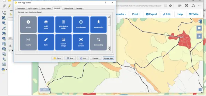
QGIS 2.14.1 Now Available from Boundless!
Boundless QGIS 2.14.1 is out the door! We are excited to share with your the latest offering of premier open-source desktop GIS technology. This release is available here and is
Boundless Sponsors American Geographical Society’s New AGS AP Teachers Fellows Program
Grant supports AP Human Geography teachers attending the AGS Annual Symposium Washington D.C – April 18, 2016 Boundless, the world leader in commercially supported open source GIS software, is proud
Tri-County Health Department Honors Esri Employee for Opioid Addiction Prevention Advocacy
Story Maps Provide Information on Local Resources and Help Celebrate Those Lost to Addiction Redlands, California—Jeremiah Lindemann, solution engineer at Esri, the global leader in geographic information system (GIS) software,

PCI Geomatics Expands Partnerships in Southern Africa
MARKHAM, Ontario, Canada—April 14, 2016: PCI Geomatics, a world leading developer of remote sensing and photogrammetric software and systems, announced today a renewed partnership with its reseller for Southern Africa.

Orbit GT Launches New UAS Mapping Software at SPAR
April 11, 2016 – Orbit GT will be launching new UAS Mapping software at the upcoming SPAR event in Houston, USA. “We’re very pleased to announce that our UAS Mapping
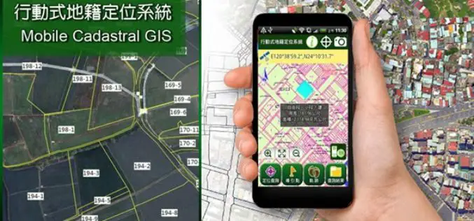
Smart Mobile Solution for Cadastral Mapping, Time to Go International!
It’s time to announce the next huge leap of SuperGIS Mobile Solution! The well-known Mobile Cadastral App powered by Supergeo, one of the best-selling land management and cadastral survey work

Vricon and Japan Space Imaging Partner on Bringing High-res 3D and Elevation Geodata Products to Japan
McLean, VA – 6 April 2016 —Vricon has announced it has selected Japan Space Imaging Corporation (JSI) for an exclusive reselling agreement. JSI is appointed as Vricon’s distributor in Japan

Leica Geosystems Smart Antenna Provides Superior Performance
Static, long term projects requiring a high number of sensors now have a new affordable smart antenna. This same device can also enable dynamic monitoring with up to 10 Hz data

