
Business
Boundless Donates $100,000 to LaunchCode in Support of CoderGirl Education Program
Donation Will Be Used to Support and Expand Program Throughout the St. Louis Area NEW YORK – August 29, 2017 – Boundless, the leader in open GIS, today announced that it

Terra Drone Dedicated Image Processing Software Terra Mapper Begins Sales of Its Cloud Version and Desktop Version at the Same Time
Terra Drone dedicated image processing software “Terra Mapper” begins sales!! ~Cloud version and desktop version release at the same time~ Terra Drone Co., Ltd. (Head Office: Shibuya-ku, Tokyo, CEO: Tokushige

Icaros and Agrowing Announce Integrated Drone Multispectral Mapping Solution for Agriculture
FAIRFAX, Virginia, USA / Tel Aviv, Israel, 29 August 2017 – Icaros Inc., a leading provider of aerial imaging software, and Agrowing, a leading supplier of multispectral sensors and analytics software, are pleased

Geospatial Corporation Completes Mapping Of Pipelines Under the Savannah River
PITTSBURGH, Aug. 24, 2017 /PRNewswire/ — Geospatial Corporation (OTCQB Symbol “GSPH”) announces that the Company has completed the mapping of three pipelines under the Savannah River for an industrial facility in Savannah,

Work Easier with Satellite Images – LandViewer Launches New Features
MENLO PARK, Calif. – The California-based company EOS have launched cloud based tool LandViewer, that allows non-expert users to select a geographic area for analysis, an earth observation data types,
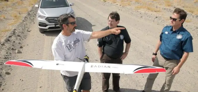
Advanced Artificially Intelligent Unmanned Aerial System (UAS) With Microsoft Researchers
Hawthorne, N.V. (August 10, 2017) – The Nevada Governor’s Office of Economic Development (GOED) and the Nevada Institute for Autonomous Systems (NIAS) has teamed up with Microsoft’s Unmanned Aerial System (UAS)

South Dakota State University Ranks 27th in World for Remote Sensing Research
AUGUST 21, 2017 – South Dakota State University was ranked 27th worldwide and 7th in the United States for research productivity in the area of remote sensing, according to ShanghaiRanking’s 2017
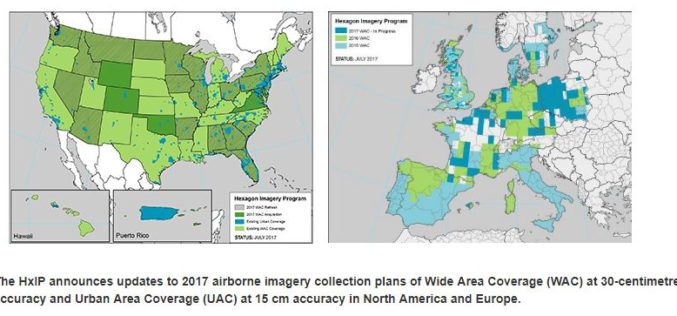
Hexagon Imagery Program Announces Updates to 2017 Airborne Imagery Collection Plans
Latest imagery collection covers U.S., Canada, Europe, plans include territories, cities (WASHINGTON, D.C., Aug. 15, 2017) – The Hexagon Imagery Program (HxIP), the premier source for professional airborne imagery provided
TerraGo Adds TopCon® GNSS Receiver Integration to Mobile Data Collection Platform
With TerraGo Magic, partners and customers can build custom mobile apps integrated with Sokkia high-accuracy receivers that deliver RTK cm-level performance to smartphones and tablets Washington, D.C. – August 14,

UrtheCast Announces the Signing of a Contract exceeding $100M for the Delivery of a SAR-XL Satellite as an “Accelerator Mission” for the OptiSAR™ Constellation
VANCOUVER, Aug. 14, 2017 /CNW/ – UrtheCast Corp. (TSX:UR) (the “Company”) announced today that it has entered into a contract with a confidential customer for the development and delivery of

