
Business

German DIN Supports Foundations of Datacubes
January 2019 – What is a coverage, after all? This fundamental spatio-temporal data structure, encompassing (among others) datacubes, is widely used, based on adopted and implemented OGC and ISO standards

Successful Launch of Formation-Flying Microsatellite Constellation Built by Space Flight Laboratory
TORONTO, Ontario, Canada, 7 January 2019 – Space Flight Laboratory (SFL) announced the successful launch of three formation-flying microsatellites built by SFL under contract to Deep Space Industries for HawkEye

Public/Private Datacube Partnership Launched
Datacubes are trending, and with the rasdaman datacube engine, they can even be federated across data centers. Users benefit from location transparency and planetary-scale fusion services. Now public and private
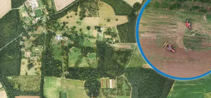
Bluesky Aerial Photomaps Help Outfield Reveal Secrets to Improving Farm Management
December 4, 2018 – Ultra high-resolution aerial photography and 3D landscape models from Bluesky are helping Outfield Technologies develop innovative image recognition techniques to improve agricultural land management and crop

HawkEye 360 Announces Successful Launch of First Three Satellites
The First Company to Commercialize RF Analytics Derived From Formation-Flying Satellites Herndon, Virginia (December 3, 2018) — HawkEye 360 Inc. today announced the successful launch of the company’s Pathfinder mission —
HERE Location APIs and Services Now Available to Developers on AWS Marketplace
HERE location platform integrated within AWS Marketplace Enterprise-grade, SLA-backed location services powered by the HERE location platform Up to 250k transactions per month for free, including commercial use November 27,

Bluesky uses Leica CityMapper to capture major UK cities in 3D
Heerbrugg, Switzerland, 21 November 2018 – Leica Geosystems, part of Hexagon, announced today the Leica CityMapper, the world’s first hybrid airborne sensor combining vertical and oblique aerial imagery together with
Leica Geosystems Offers New Utility Surveyor Course
Heerbrugg, Switzerland – 20 November 2018 – Leica Geosystems, part of Hexagon, announced today the launch of a new five-day Utility Surveyor Course provided at its Detection Training Campus in Stoke-on-Trent, Staffordshire, UK. To
Virtual Surveyor 6.1 Handles More Than Drone Data
Saves Time and Money on Extra SW LEUVEN, Belgium, 13 November 2018 – Virtual Surveyor, the popular drone surveying software, has eliminated the need for clients to use third-party applications
Orbit GT Upgrades 3D Mapping Cloud to Support Meshes, DEMs
“I’m pleased to announce yet another great update for our popular SaaS platform from the Smart City Expo and World Congress in Barcelona”, says Peter Bonne, CEO of Orbit GT.

