
Business

NASA-CNES Move Forward with Global Water and Ocean Surface Mission
NASA and the French space agency Centre National d’Études Spatiales (CNES) have agreed to jointly build, launch, and operate a spacecraft to conduct the first-ever global survey of Earth’s surface

Supergeo Establish User Network with Evolving Geosystems in UAE
Supergeo Technologies, a leading global provider of GIS software and solutions, announces the official reseller agreement with Evolving Geosystems Technologies (EGT) to keep providing high-quality total SuperGIS solutions in UAE.
Smart Mapping SuperSurv Available on App Store and Google Play Now
Supergeo Technologies, a leading global provider of GIS software and solutions, launches SuperSurv, the mobile GIS app, on the App Store and Google Play.Containing comprehensive GIS data collection functions, SuperSurv

PR: Bulgarian Ports Infrastructure Company Implements Hexagon Geospatial Technology to Enhance Shipping
May 06, 2014 GeoMedia® WebMap and GeoMedia® Play Key Role in Visualizing Port Data Norcross, Ga. (PRWEB) May 06, 2014 Hexagon Geospatial announces that the Bulgarian Ports Infrastructure Company is

TerraGo Workgroups Brings the Power of GeoPDF® to Small Organizations and Teams
Company launches TerraGo Workgroups to bring GeoPDF collaboration capabilities to ArcGIS® customers with flexible, cost-effective subscriptions that meet their unique requirements. Washington, D.C. – April 28, 2014 – TerraGo announces the
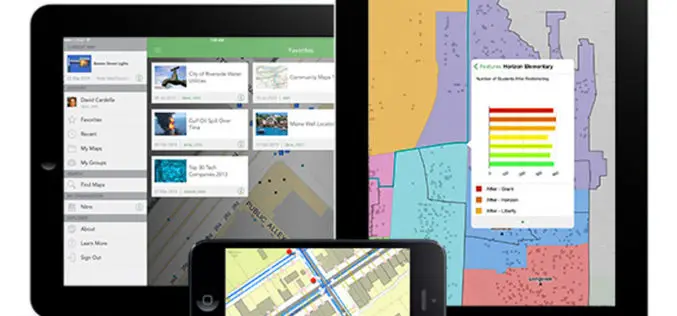
Explorer for ArcGIS Brings GIS to Everyone
Mobile App Simplifies Discovery, Visualization, and Sharing of Maps Redlands, California—Esri recently released the definitive GIS app for everyone to access and share maps on their smartphone and tablet. Called

SuperGIS Desktop Assists Geo-Sol, South Africa, in Efficient GIS Processing
Supergeo Technologies, a leading global provider of GIS software and solutions, announces that Geo-Sol, South Africa chooses SuperGIS Desktop 3.2 for high-efficiency GIS data processing and spatial analyses for earth

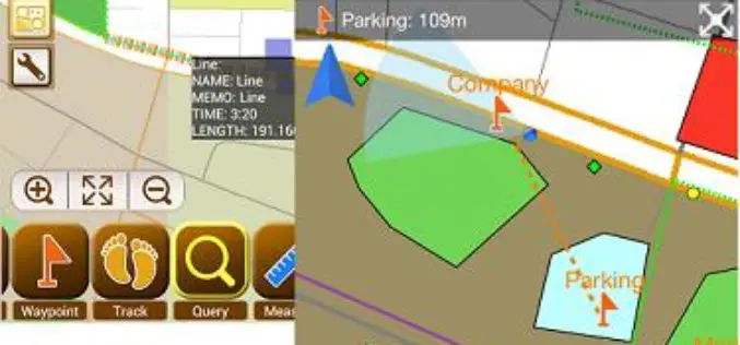
Android-Powered Mobile GIS, SuperSurv 3.1a, Supports Auto Positioning
Supergeo Technologies, a leading global provider of GIS software and solutions, announces that SuperSurv 3.1a for Android, the data collection app, now supports Auto Positioning to provide users with a

The OGC® adopts OGC Geo and Time Extensions Standard for OpenSearch
The Open Geospatial Consortium (OGC®) Members approved “OGC OpenSearch Geo and Time Extensions” as an OGC standard. This document defines an extension to the popular OpenSearch specification so that users

Ordnance Survey Signs New Agreement with Openreach
Ordnance Survey has entered into a new five-year agreement with Openreach (a part of BT Group) worth over £23 million for the supply of a range of data products, services and

