
Business
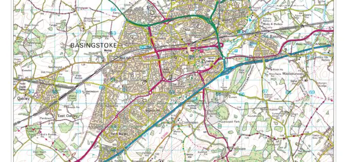
Digimap for Schools Launches 1950s Maps of Great Britain
Digimap for Schools now has a second historic map layer added to its popular online service, giving teachers and pupils direct access to Ordnance Survey mapping from three centuries. Covering the

FAA Expands Unmanned Aircraft Pathfinder Efforts
The Federal Aviation Administration (FAA) has entered into a Pathfinder agreement with CACI International Inc. to evaluate how the company’s technology can help detect Unmanned Aircraft Systems (UAS) in the

Ordnance Survey Selects SimActive’s Correlator3D
SimActive Inc., a world-leading developer of photogrammetry software, is pleased to announce the purchase of Correlator3D licenses by Ordnance Survey, the UK government agency responsible for mapping. Ordnance Survey had

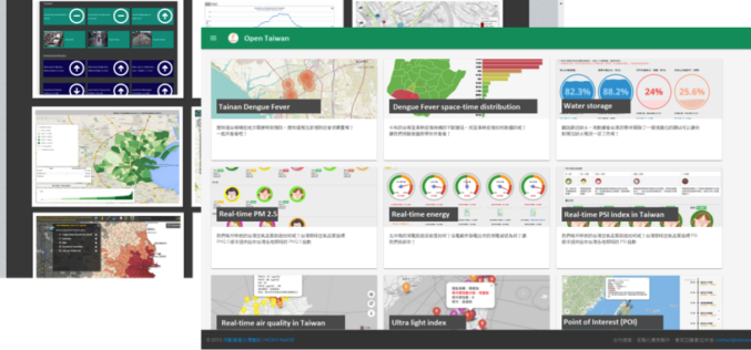
Geospatial Data in Taiwan – Focus on Integration
Supergeo’s biggest application customer in Taiwan, Ministry of the Interior and the TGOS platform, has just announced one of the biggest projects in the GIS field from ide@ Taiwan 2020

GIS Partnership to Aid Removal of Land Mines
Geneva International Centre for Humanitarian Demining to Employ Latest Esri Mapping Technology in Worldwide Efforts Redlands, California—Esri and the Geneva International Centre for Humanitarian Demining (GICHD) signed a memorandum of

LizardTech Publishes Industry Survey Results on Raster Imagery and LiDAR Data Challenges
LizardTech, the creator of MrSID® and provider of software solutions for managing and distributing geospatial content, has published the results of a survey into the preferences and challenges of raster and
A World of Open Data
Nowadays, people are asking eagerly for Open Data and Open Government in order to gain access to unmediated facts and knowledge. Open data is, in fact, not a new idea.

Successful Launch for interaerial SOLUTIONS
Karlsruhe, 6 October 2015 – The interaerial SOLUTIONS communications platform premiered at INTERGEO 2015 in Stuttgart really took off with exhibitors and visitors alike. Unmanned aircraft system (UAS) manufacturers and

Esri and Trimble Offer the R1 GNSS Receiver to Enhance Field GIS Workflows
Professional-Grade GPS Accuracy Now Available for Collector for ArcGIS App Redlands, California—Esri announced today the availability of the Trimble R1 Global Navigation Satellite System (GNSS) receiver for collecting professional-grade GPS

BAE Systems to Develop Airborne Mine-Hunting LIDAR for Manned and Unmanned Aircraft
Electro-optics engineers at BAE Systems are designing a multi-sensor suite and onboard processing to detect, identify, and pinpoint moored and drifting sea mines from manned and unmanned aircraft. Officials of the
