
GIS Data
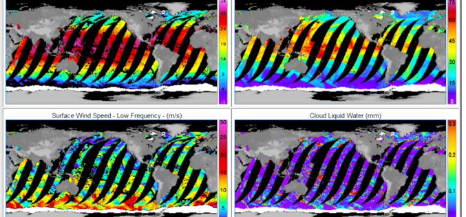
GPM Microwave Imager Data Products are Now Available to Download
Remote Sensing Systems has just released the GPM Microwave Imager (GMI) ocean product suite. The Global Precipitation Measurement (GPM) satellite has a microwave radiometer onboard called GMI (GPM Microwave Imager). The
Esri Updated Standard Global Demographic Data for 45 Countries
Esri has updated the Standard Global Demographic data for the 45 countries and is now available on the ArcGIS platform. The data is sourced from Michael Bauer Research, is available across the ArcGIS
UK Environment Agency Make LiDAR and Environment Data Open for All
The UK Environment Agency (EA) is to make its LiDAR datasets freely available as open data to commercial entities from September this year. Since 2013, LiDAR data has been published for non-commercial
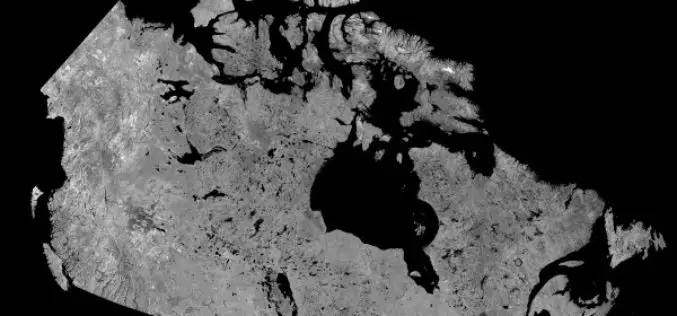
Download Free RADARSAT Data of Canada
Canada’s RADARSAT-1 is a radar satellite and was launched in November 1995. It carries a Synthetic Aperture Radar (SAR), it acquired images of the Earth day or night, in all
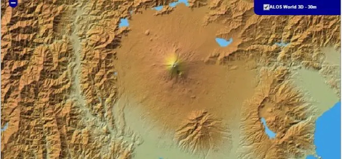
30 meter World Elevation Data is Now Available at JAXA’s Site Free of Charge!
The Japan Aerospace Exploration Agency (JAXA) will begin publishing free of charge an elevation data set that can express undulations of terrain over the world with a resolution of 30
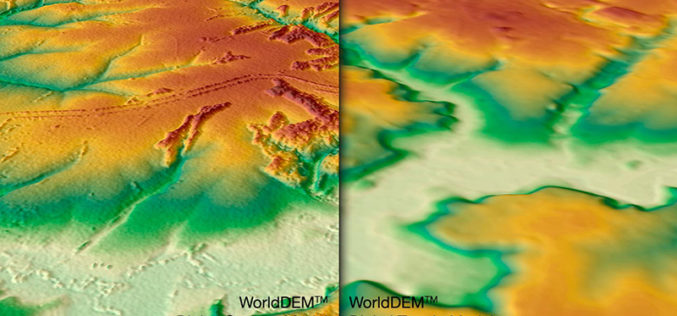
WorldDEM DTM Now Available
Precise Terrain Information Globally for Effective Analysis The WorldDEM Digital Terrain Model (DTM) is now commercially available for all users that need superior terrain information anywhere on the globe. The

Explore and Download Berlin 3D City Model
The 3D city model of Berlin the German capital is open to the public as Open Data. The Berlin 3D city model data plays a leading role throughout Europe in the
New ASPRS Positional Accuracy Standards for Digital Geospatial Data Released
The American Society for Photogrammetry and Remote Sensing (ASPRS) is pleased to announce the release of the new Positional Accuracy Standards for Digital Geospatial Data. The new standards are available
Esri Releases Demographic Data for 137 Countries
Global Income, Population and Business Data Now Easily Available for Better Local Market Knowledge Esri announces that geodemographic information for 57 additional countries has been added to its ready-to-use ArcGIS

Enhanced Elevation Data for North and South America, Pacific Islands, Northern Europe
New Heights of Global Topographic Data Will Aid Climate Change Research The U.S. Geological Survey announced today that improved global topographic (elevation) data are now publicly available for North and
