
Posts From GIS Resources

Terra Drone Dedicated Image Processing Software Terra Mapper Begins Sales of Its Cloud Version and Desktop Version at the Same Time
Terra Drone dedicated image processing software “Terra Mapper” begins sales!! ~Cloud version and desktop version release at the same time~ Terra Drone Co., Ltd. (Head Office: Shibuya-ku, Tokyo, CEO: Tokushige

Icaros and Agrowing Announce Integrated Drone Multispectral Mapping Solution for Agriculture
FAIRFAX, Virginia, USA / Tel Aviv, Israel, 29 August 2017 – Icaros Inc., a leading provider of aerial imaging software, and Agrowing, a leading supplier of multispectral sensors and analytics software, are pleased

Trimble Webinar: TBC Power Hour – Network Adjustment vs. Traverse Adjustment
TBC Power Hour – Network Adjustment vs. Traverse Adjustment AUGUST 30, 2017 | 08am MT or 04pm MT Geospatial Webinars offer attendees the opportunity to learn more about products, explore

China, Russia to Sign Agreement to Boost Space Cooperation
Beijing, Aug 28 (IANS): China and Russia are set to sign a milestone agreement on joint space exploration from 2018 to 2022, the media reported on Monday. The deal is expected
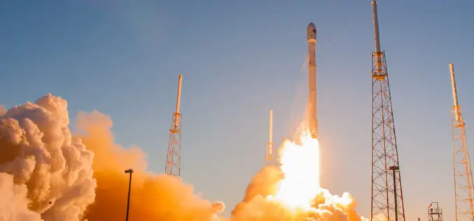
SpaceX Falcon 9 Successfully Launched Taiwan’s Formosat-5
A SpaceX Falcon 9 successfully launched a long-delayed remote sensing satellite for the government of Taiwan Aug. 24, executing another first stage landing in the process. The rocket’s only payload,

Geospatial Corporation Completes Mapping Of Pipelines Under the Savannah River
PITTSBURGH, Aug. 24, 2017 /PRNewswire/ — Geospatial Corporation (OTCQB Symbol “GSPH”) announces that the Company has completed the mapping of three pipelines under the Savannah River for an industrial facility in Savannah,

Work Easier with Satellite Images – LandViewer Launches New Features
MENLO PARK, Calif. – The California-based company EOS have launched cloud based tool LandViewer, that allows non-expert users to select a geographic area for analysis, an earth observation data types,
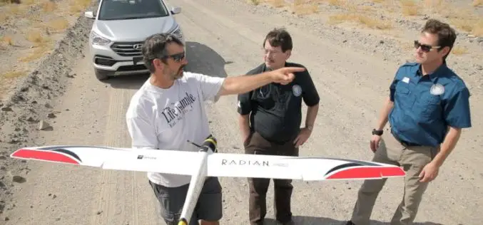
Advanced Artificially Intelligent Unmanned Aerial System (UAS) With Microsoft Researchers
Hawthorne, N.V. (August 10, 2017) – The Nevada Governor’s Office of Economic Development (GOED) and the Nevada Institute for Autonomous Systems (NIAS) has teamed up with Microsoft’s Unmanned Aerial System (UAS)

Malaysian Geospatial Master Plan to be Completed in 2018
August 22, 2017 – Putrajaya, Malaysia: The Natural Resources and Environment Ministry (NRE) is developing the National Geospatial Master Plan (NGMP) towards realising the potential of geospatial technology, in line with the

South Dakota State University Ranks 27th in World for Remote Sensing Research
AUGUST 21, 2017 – South Dakota State University was ranked 27th worldwide and 7th in the United States for research productivity in the area of remote sensing, according to ShanghaiRanking’s 2017

