
Posts From GIS Resources

Skyfront Sets World Record for Drones with 4 Hour and 34 Minute Flight
Skyfront invents hybrid-electric drone technologies to enable monitoring of large, remote assets in challenging terrain for the Utility, Agriculture and Energy industries. MENLO PARK, CA, SEPT. 12, 2017 – Skyfront,

How Will Ag Technology Revolutionize Global Food Production?
How Will Ag Technology Revolutionize Global Food Production? Find out at the second annual PrecisionAg® Vision Conference Final Agenda delivers high-impact keynotes, track for specialty crops, Arizona field tour Willoughby,
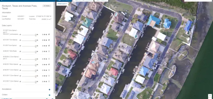
New Airbus Aerial Technology Impacts Hurricane Irma Recovery Efforts
September 12, 2017 – As residents and insurers in the southeastern United States begin to consider recovery efforts following Hurricane Irma, Airbus Aerial is prepared to help by providing insurance
PCI Geomatics Releases Geomatica 2017, Service Pack 1
MARKHAM, Ontario, Canada, September 12, 2017 – PCI Geomatics, a world leading developer of remote sensing and photogrammetric software and systems, announced today the release of Service Pack 1 for
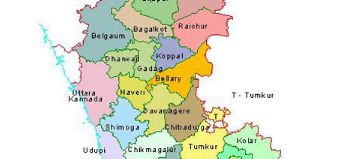
12 Taluks of Karnataka to get Soil Condition Map
According to recent news by The Hindu Business Line, the National Bureau of Soil Survey and Land Use Planning (NBSSLUP) is working on a project to map soil in 12

India, Afghanistan to Cooperate in Space Technology
India will widen cooperation with Afghanistan in space technology by extending assistance in remote sensing, a joint statement after the 2nd Strategic Partnership Council Meeting between two nations said. India
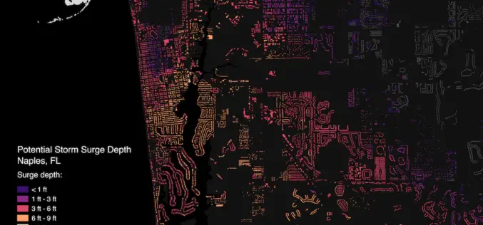
Brainnwave Makes Data Available to Support Disaster Relief
September 12, 2017 – Brainnwave believe that people make better decisions if they have quick and simple access to the data they need, at the time they need it. With

Indian Railways to Install GPS in all Hand-pushed Trolleys Used for Track Inspection
September 8, 2017 – PTI – The railway ministry has decided to install GPS trackers in all hand-pushed trolleys used to inspect the tracks. In a letter to all zonal

OGC Approves Community Standard for Streaming 3D Content
September 06, 2017 – The Open Geospatial Consortium (OGC®) membership has approved a new 3D standard for content strategy. This standard is focused on high performance visualization and spatial analysis

Pix4D Among UAV Industry Leaders Intel® Uses to Launch Intel Insights Platform
September 7, 2017 – Yesterday at InterDrone, Intel CEO Brian Krzanich announced the new Intel Insight Platform that will allow select enterprise customers to accelerate the path from drone flight to

